 |
|
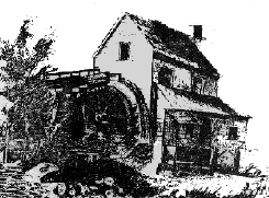
Sketch of mill
near Mission San Jose |
The region that is
now known as the Mission area in Fremont, was a majestic site for
early visitors. During sunrise, golden rays would outline a
silhouette of a grand peak, slowly revealing itself in the eastern
horizon. The burly live oaks, slender cottonwood, and contorted
sycamore trees outlined the meandering creeks that started part way
up the flanks of the mountain. Fragrances from the California
buckeye and bay laurel trees mixed with the potpourri of
wildflowers, made early visitors think they were in paradise.
Water in this area
originated from bubbling springs, that mystically appeared from
groundwater. Water would ooze out along contorted layers of
sandstone that peeked through the soil. The water flowed from the
Mission area and slowly made its way toward what is now called the
San Francisco Bay.
This sight was
witnessed during the Pleistocene, by mammoths, mastodons, sabercats,
camels, and sloths that roamed the savannah type flatlands closer to
the bay. All these organisms used the waters that flowed through
this area. The landscape changed through time. The hills became
taller with each new shake from an earthquake, which constantly
changed the course of the creeks.
 |
|
Sloth that lived
in the Fremont area |
The larger animals
became extinct, probably due to climatic change. Slowly new visitors
to the area, like the Ohlone Indians, saw a perfect area to live.
There was a constant source of water and a place to hunt, as animals
came to drink along the creeks.
A survey party of
soldiers along with Father Antonio Danti in 1795, were looking for a
place to operate a new mission. They recommended this golden area
with the fertile land and free flowing streams that could support
crops and cattle.
In 1797, Father
Fermin de Lasuen founded Mission San Jose. They quickly diverted
water from three creeks to serve their new living and working
quarters. The Ohlone Indians were recruited to create a reservoir
above the mission, and started an extensive system of clay pipes to
water the crops and serve the Mission San Jose. A large flour mill
was erected across the main creek in the early 1800's. A large
fountain in the Missions plaza was erected for bathing and washing.
 |
|
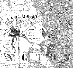
Mission
creek is shown to enter Stivers Lagoon
in the 1878 map.
(click on picture to enlarge) |
The creeks would
never again flow freely along the flanks of Mission Peak, as humans
diverted the water for their use as the area prospered. The Mission
San Jose Water Company sold water in 1878 to customers of the
growing cities to the north (Oakland and San Francisco). Juan
Gallegos and his prosperous Palmdale Winery would use the waters to
nourish miles of grape crops for decades.
 |
|
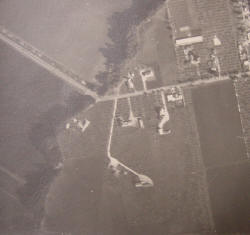
Area photograph
of Palm Ave.
Near Mission San Jose High School
portion of creek (1956)
(Click on picture to enlarge) |
However the
extensive use of water, which was stored in the pores of the
sandstones below the Mission area, could not supply the creeks
forever. Every season the water flows diminished. The creeks, which
flowed year round from the underground springs, were now dependant
on humans to store water in small reservoirs to keep the streams
alive. The remnant of this glorious wet past is now preserved as
Mission Creek. This creek feeds into Laguna Creek that begins around
the present-day Lake Elizabeth and flows toward the bay. Hence this
region is part of the Laguna Creek watershed within the City of
Fremont.
In the 1960's as
this area became the City of Fremont and Alameda County became
responsible for "flood control," these creeks became part of a
system to again serve the people. Lake Elizabeth was created from
what was then referred to as "Stivers Lagoon."
In the late 1990s
a group of agencies decided to restore a portion of Mission Creek
between Palm Ave and Driscoll Road. The restoration was completed
in 2003, and only time will tell if it is successful. |