|
Mission Creek dissects 5 geologic units including the Briones
Formation (Miocene), the Tice Shale (Miocene), the chert and
siliceous shale member of the Claremont Formation (Miocene), older
alluvial fan deposits (Pleistocene), and flood basin deposits
(Holocene). A formation is a geologic term that includes rocks
that were deposited under similar conditions over a large area.
Erosion occurs predominantly in the hills where the Briones
Formation, Claremont Formation, and the Tice shale are exposed, but
erosion also occurs in the older alluvial fan deposits.
Sedimentation occurs further down the creek in the flood plain
deposits and in Lake Elizabeth.
Mission Creek is located within the area covered by the Niles and La
Costa 7.5-Minutes Quadrangles, which are maps produced by the U.S.
Geological Survey. Thomas Dibblee completed the first preliminary
geologic maps in 1980. Graymer, et al (1994), in his preliminary
geologic map of the Niles 7.5 Minutes Quadrangle did not assign a
name to the Cretaceous sediments, but correlated the Miocene
sediments with those found further north in the Berkeley area and
assigned them the unit and formation names common in the Berkeley
Hills. The aerial extent of the geologic units in Graymers map
differs little from Dibblees in the Mission Creek area. His
descriptions of the map units are more detailed and show some
differences to Dibblees. The interpretation of the structure in the
area is also interpreted differently. While Dibblee recognizes a
syncline (Niles Syncline) and an anticline in the Cretaceous and
Miocene sandstone units, Graymer sees them as faults, the Sheridan
Creek fault and the Dresser Fault/Mill Creek Fault respectively.
Dibblee interprets the layers of Miocene sandstones between Mission
fault and the anticline northeast of Mission Fault as being
overturned and dipping northeast. Graymer sees these layers as just
dipping to the northeast between Mission Fault and Mill Creek Fault.
Below is a summary of the units of Graymer, et al (1994). The codes
can help you find them on the simplified geologic map in this book.
UNNAMED (Holocene) (QTig, Qhaf, Qhb, Qhf, Qhsc, Qls)
Organic-rich clay to very fine silty-clay deposits occupying the
lowest topographic position either between the Holocene levee
deposits or Holocene flood plain deposits.
UNNAMED (Pleistocene) (Qpaf)
Tan to reddish brown, dense, gravel to clay sands or clayey gravel
that grades upward to sandy clay.
BRIONES FORMATION (late Miocene) (Tbu)
The basal part of this formation consists of distinctly bedded, gray
to white fine-grained sandstone and siltstone. Bedding is parallel
and cross-beds are not evident. Sandstone beds are as thin as 5 to
10 cm with 2 to 10 cm thick shaly interbeds. These are interbedded
with massive fine-grained sandstone beds as much as 5 meters thick.
The middle part of the formation (shell beds) consists of
indistinctly-bedded, white, fine to coarse-grained sandstone,
conglomeratic sandstone, and massive, shell-hash conglomerate.
Shell-hash conglomerate is made up of marine mollusk shells in a
white calcareous sandstone matrix. Pebble and cobble conglomerate
beds are present in a few places. Conglomeratic clasts include black
chert, red chert, quartzite, andesite, argillite, siltstone, basalt,
felsic tuff, and vein quartz. The shell beds and conglomerates are
hard and resistant and form prominent ledges, ridges and peaks such
as Mission Peak. The upper portion of the formation consists of
distinctly indistinctly-bedded, massive to cross-bedded, fine to
coarse-grained light colored sandstone. Sand grains are
predominantly quartz and feldspar.
CLAREMONT FORMATION (middle to late Miocene) (Tcc, Tcs)
Chert occurs as distinct, massive, gray beds as much as 10 cm thick
with thin (about 1 to 2 mm) shale partings. Chert forms about 30 %
of the member in the Niles quadrangle. Siliceous shale is dark brown
to gray, finely laminated, with grains ranging from clay to silt
size.
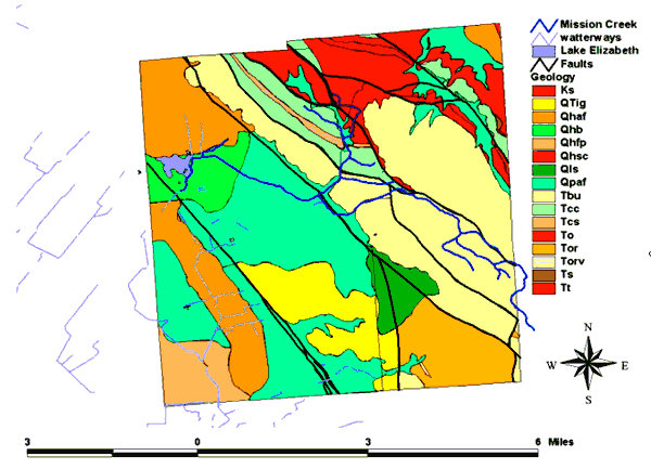
Simplified geologic map of Mission Creek
Watershed
OURSAN SANDSTONE (To)
Distinctly to indistinctly - bedded black mudstone, and foraminifera
- bearing, brown to tan siltstone and fine -grained sandstone. In
places these rocks have a large amount of secondary calcite. The
Oursan is distinguished from the Briones and Claremont Formations by
its darker color, finer grain size, and presence of Foraminifera in
siltstone, sandstone and dolomite. In this area it is 300 to 1000
meters thick.
ORINDA FORMATION (Tor,Torv)
Distinctly to indistinctly bedded pebble to boulder conglomerate,
conglomeratic sandstone, and coarse to medium - grained lithic
sandstone. At least 1500 meters thick in this area, although the
base and top are not exposed in continuous space. It is easily
distinguished from other conglomerates in the area by the red and
green color.
SOBRANTE FORMATION (Ts)
White, fine to medium grained quartz sandstone. Occurs in
discontinuous outcrops below the base of the Claremont Formation in
the eastern part of the quadrangle, nowhere more than 120 meters
thick, in fault contact with underlying Cretaceous rocks.
TICE SHALE (middle Miocene) (Tt)
Distinctly bedded, dark brown, gray and tan, siltstone, mudstone and
siliceous shale. Tice shale weathers in place to a reddish brown
color, and in places contains abundant fish scales. The shale also
contains numerous lenses of massive, tan dolomite, as much as 2 m in
length that weathers to a characteristic bright orange color. Many
of the dolomite lenses contain Foraminifera that are evident on
weathered surfaces of the rock. Tice shale has a maximum thickness
of 290 m in this area. Tice shale is similar to shale in the
Claremont Formation in the Niles Quadrangle, but lacks the chert
beds characteristic of the Claremont.
UNNAMED (Cretaceous)
Distinctly bedded gray to white, well lithified, massive to cross
bedded, micaceous, coarse to fine grained sandstone, siltstone and
shale. Sandstone varies from granitic (quartz, feldspar, and biotite
grains) to lithic wacke (grains of mica, clay, quartz, feldspar and
lithic fragments). Sandstone and shale beds are interfingering and
range from several cm to several meters thick. In some places the
shale contains small (10 cm) to large (1-2 m) limestone concretions.
Poorly preserved foraminifera are present in many shale outcrops,
and plant debris is common. Sandstone tends to form outcrops on the
ridges and uplands, and prominent resistant outcrops in canyons,
whereas the shale interbeds are largely visible only in canyons.
|