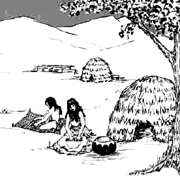
Before William Tyson purchased this property in the late 1800’s, this was part of a large Mexican land grant called Ex-Mission San Jose. The land was given to Juan Bautista Alvarado and Andres Pico in 1846 by the Mexican government. Their ownership was nullified by the United States Land Commission in the late 1850’s allowing people who were settling in the area to purchase land for $1.25 an acre. Prior to the Mexican land grab, the area was occupied by the Spaniards, who referred to this as Mission San Jose. The Ohlone Indians, who settled this area before the Spaniards, used this marshy area to hunt and harvest the tules to make homes, baskets, boats, and toys. The lagoon was probably larger and connected to the marshy area that we now refer to as Stivers Lagoon. The harvest of the tules during the fall would allow new homes and boats to be made. The cattails were also harvested and used for food and weaving.
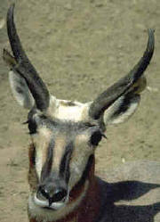
But before humans arrived in this area it was the home of many animals including sabercats, dire wolves, sloths, mastodons, bears, mammoths, prongbucks, and camels. These Pleistocene prehistoric animals enjoyed a savannah type environment with weather that is wetter than today. There is plant evidence that cattails, willows, and oaks were abundant in the area as well as freshwater clams, snail, and fishes. There is even evidence for the western toad, western pond turtle and many of the same birds that are present today. Small mammals like the white-foot mouse, vole, pocket mice, wood rats, squirrels, gophers, and rabbits were also part of the Pleistocene landscape. Whether this area during the Pleistocene, was a pond has not been verified. However, since the Hayward fault system was active, it is likely that these animals drank water from the Tyson Lagoon waters. We know that the aquifers (water trapped as ground water) were being created as geological processes trapped water in permeable rock layers. These underground layers are collectively called the Niles Cone. This water provides about 1/3 of the drinking water in southern Alameda County.
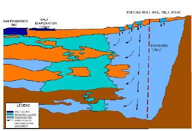
Tyson Lagoon has been a site of fresh water for at least the last 3700 years (Lienkaemper, et al, 2002). This sag pond outlines the trace of the Hayward fault zone in this area. Looking at brittle deformation and liquefaction features in trenches just north of this area, Williams (1993) concluded there may have been 6-8 large earthquakes during the last 2000 years. Lienkaemper, et al, with new data concluded that since late 1300’s there were probably 4 large earthquakes (of magnitude 6.8-7.0) In trenches in the South Pond they found evidence of the 1868 earthquake. The earthquake destroyed most of the Mission Adobe structure and devastated the homes of many of the residents. Using detailed stratigraphy and carbon dating they arrived at dates of 1730, 1630, and 1470 (±90 years) for the other earthquake occurrences. Detailed trenching in the south pond of Tyson Lagoon by the U.S. Geological Survey have identified other earthquakes that occurred in the past. They use data derived from trench logs, radiocarbon, pollen, and detailed sedimentogical data. The trenching has exposed typical pond sediments, including well-bedded deposits of silty clay, interbedded with organic layers including shell hashes, and slightly coarser, less organic silts to sandy silts. The composition and structure of the deposits indicate a rapidly subsiding, shallow aquatic environment that was subject to seasonal drying. Evidence of creeping along the fault has been calculated with an average slip rate of 9± 2mm/yr (Leinkaemper and Borchardt, 1996)
From these studies other information on the environment can be derived. The first nonnative pollen of Erodium cicutarium (red-stemmed filaree) probably coincides with the arrival of Spanish in 1776 (Mensing and Byrne, 1998). Sharp contact and layers of shells in sediments deeper than 3.5 meters imply a larger body of standing water than present.
Tyson Lagoon today is about 100 meters wide, 300 meters long, and 2 meters deep. During the rainy season the surface area doubles in size from 3 to 6 acres with a depth of 3 meters. It drains approximately 40 percent of the Mowry Slough watershed. The lagoon is classified as a permanent warm water sag pond (F1212) by the California Department of Fish and Game. A sag pond is caused by percolation of water along a fault. Tyson Lagoon lies on the Hayward fault. A small patch of undeveloped land located just east of the Fremont BART (Bay Area Rapid Transit) station, receives the run off of approximately seven hundred acres. In the 1950’s it was modified by Alameda County Public Works to serve as flood control for this lowland area. In the 1960’s further modification was done because of the addition of the BART station. In 1998, the lagoon was modified as a constructed wetlands to help clean water run off before it goes into the San Francisco Bay. William Tyson
In the fall of 1841 he came to the United States and settled in Columbus City, Iowa. It was his desire to come to the land of his dreams. He worked as a wagon maker. In 1847 he married Emmeline Morrison and moved to Port Louisa in Iowa. The gold rush in California motivated Tyson to move with his wife, infant son, and his brother-in-law, William Morrison, to seek his fortune. Mr. Tyson lead the party of 19 wagons to the west. He acted as a scout and hunted for game. It was remembered that he shot the first buffalo that people in his party had ever eaten and killed five pheasants in one shot. During the travel west their young son died. The Tyson Family stopped at Hangtown (now known as Placerville) in El Dorado County and opened a boarding house. The story goes that after only three weeks Mr. Tyson and his brother-in-law bought a gold claim for $300.00. They soon sold the claim to make quick money. A series of unfortunate events convinced Tyson to go to Sacramento to start a grocery store, which was not successful. He again opened a boarding house. In 1850 he received a letter from his brother-in-law, Perry Morrison from San Jose Valley. The letter convinced Tyson to move to Mission San Jose, where he purchased a beautiful tract of land near Alameda Creek. The land that he owned included wetlands as well as good farmland. He brought his six sons and three daughters to this peaceful place. The Tyson’s celebrated their silver anniversary in 1872. Compared to his earlier years of hardship, his life was peaceful. He rarely left this area. He died in his home in Niles. |


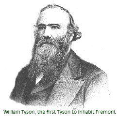 William Tyson, one of eight children, was born in the
northwestern corner of England near Scotland, on December 5, 1820.
Although his family were mainly dairymen, William apprenticed as a
carpenter and became a house carpenter, joiner, and wagon-maker before
he was 21.
William Tyson, one of eight children, was born in the
northwestern corner of England near Scotland, on December 5, 1820.
Although his family were mainly dairymen, William apprenticed as a
carpenter and became a house carpenter, joiner, and wagon-maker before
he was 21.