|
The Science Behind the Fault
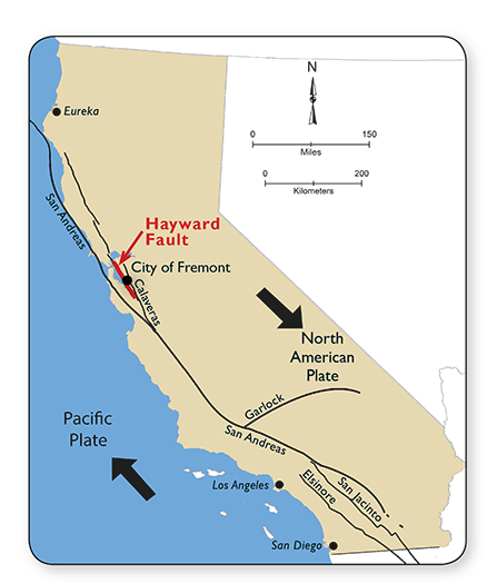 |
Major Fault Lines in California
The map shows several fault lines that exist in California.
The Pacific Plate is moving north relative to the North
American Plate, creating the San Andreas Fault System,
which also includes the Hayward Fault. This is also
called a Transform Boundary, as the plates slip and
slide pass each other.
North of Cape Mendicino the
slip/slide motion changes to converging. The
Pacific Plate is being subducted under the North
American Plate causing volcanoes as well as earthquakes.
Transform motion only has earthquakes.
In the San Francisco Bay area
the Hayward Fault is one of three major fault zones
(including the San Andreas and Calaveras) of the San
Andreas Fault System that has produced large historic
earthquakes
|
| |
|
Th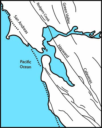 ere are many earthquake faults in the San Francisco
Bay Area. A fault is a break in the Earth’s crust,
caused by movement of rigid blocks. The Hayward
Fault dissects Fremont creating offset features. The
In 1836 there was a large earthquake but the larges was
felt on October 21, 1868. ere are many earthquake faults in the San Francisco
Bay Area. A fault is a break in the Earth’s crust,
caused by movement of rigid blocks. The Hayward
Fault dissects Fremont creating offset features. The
In 1836 there was a large earthquake but the larges was
felt on October 21, 1868.
The Hayward
Fault is an offset of the San Andreas Fault system that
dominates the landforms of eastern San Francisco Bay.
The relative motion between the North American Plate
(southeast) and the Pacific Plate
(northwest) create stress that releases energy as
earthquakes. This slip slide motion is called a transform fault.
The Hayward Fault is within the San Andreas Fault
Boundary Zone between the North American Plate and the Pacific
Plate. The Hayward
fault is one of only a few dozen faults in the world that “creeps,” or
slowly moves.
Evidence of creep can be found from Pt. Pinole in the north to
south Fremont.
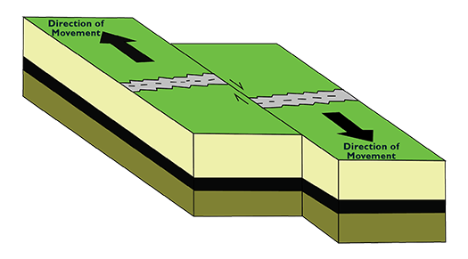
The Hayward Fault has a
strike-slip motion which is when one land mass
moves, nearly horizontally in the opposite direction of
the other on the surface. This movement causes
stress, which results in earthquakes.
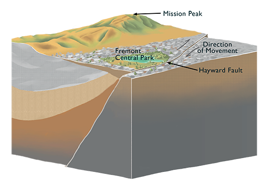
The Hayward Fault is a strike-slip fault on the surface
but changes to a low angle thrust fault as it
descends under the Easy Bay Hills. This creates an
uplift of the East Bay hills in the Fremont area
exposing the rocks of the Briones Formation, which is a
fossilerous rock made of marine shells. It is Miocene in
age and can be correlated to other similar sediments throughout
coastal California.
In the big picture, scientists know where the
fault is because of curbs and streets being offset from fault creep,
pre-development aerial photos showing creeks shifted and other
markers of fault movement, and from previous trench exposures
showing the fault below ground. Scientists can take
sonar pictures of the earth below.
 |
 |
| strike slip fault motion |
Hayward Fault going under the
East Bay Hills in Fremont area |
What is a fault creep?
- Fault creep is the slow, almost constant
movement along a fault without large earthquakes. Creep is unusual.
- Most faults around the world only slip during
earthquakes generally larger than magnitude 6.7. The Hayward Fault
slips both during those large earthquakes and also the rest of the
time from fault creep.
- The Hayward Fault in Fremont creeps about
3/16ths of an inch (5mm) per year. The fault needs to move about
6/16ths of an inch (9mm) per year to release the energy building up
at the surface.
- Fault creep is only happening in the upper
couple of miles of the fault's total 8 mile
depth, at least for most of the length of the fault. The lower part
of the fault is locked and has to release energy during bigger
earthquakes.
What happened in the last big earthquake on the
Hayward fault?
- The last big earthquake along the Hayward
Fault was in 1868. It was approximately a magnitude 6.9.
- The fault broke for about 30 miles from
around Milpitas to the Oakland-Berkeley border. The fault slipped 3
to 6 feet along the fault. The western side moved north and the
eastern side moved south.
- At the exhibit, the fault slid about 3 feet.
It was closer to San Leandro where the fault slipped about 6 feet.
This is what is likely to happen in the next big quake along the
Hayward Fault.
|
|
 |
MATH SCIENCE NUCLEUS
since 1982 has served the education and public by
offering quality science and math lessons that take our
children learn critical thinking skills. We manage the
Children's Natural History Museum and Tule Ponds at
Tyson Lagoon Wetland Center.
http://msnucleus.org.
|
 |
CITY OF FREMONT
is located in the southeast San Francisco Bay area and
straddling both the East Bay and South Bay regions.
It has a population of close to 1/4 million people and
one of the largest city by land in San Francisco Bay
area.
|
 |
U.S. GEOLOGICAL SURVEY
is a government agency that Federal
source for science about the Earth, its natural and
living resources, natural hazards, and the environment.
They provide the posters and map for the Faulted Floor
Exhibit. http://usgs.gov
|
 |
CALIFORNIA GEOLOGICAL
SURVEY was established in 1860, and one of the
oldest geological surveys in the United States, serving
as a primary source of geologic information for
California’s government agencies, businesses, and
public. |
Math/Science Nucleus
4074 Eggers Drive, Fremont, California, U.S.A., 94536
(510) 790-6284
msn@msnucleus.org
MSN Home
|
 ?
?