BACKGROUND:
Geography is the science that studies the location of objects, such as
mountains, human cultural groups, or even butterfly populations. The
location can be either Earth or space. Maps are an essential tool of
geography. Maps are a representation of the Earths surface. Topographic
maps, for example show the location and shape of mountains, valleys, and
plains; the networks of streams and rivers; and the principal works of man.
Hikers use topographic maps, especially in areas where there are no roads
with signs. Geologists depend on topographic maps for superimposing rock
types upon the land. Other examples include maps that illustrate
physiographic features such as forests, grassland, woodland, tundra, grazing
land, ocean floors, and ocean sediments. Meteorological maps that show
climate, weather and wind are types of environmental maps. Environmental
maps can also record human impacts on the environment. Meteorologists,
oceanographers, geographers, city planners, and many other professionals
depend greatly on these maps to record and forecast their specific field.
Cartography is the science of making a map. It requires a knowledge of
how to represented objects on a smaller space. Maps are smaller than
the areas they portray, otherwise, they would be useless. Imagine a map of
your city that is city-sized!.
 Distances on maps are thus smaller than the
real distances they represent. The relationship between map distance and
real distance is called a maps scale. Topographic maps show two scales. A
bar scale shows distances graphically, the diagram shows how to measure five
miles on a map. Topographic maps also have a fractional scale. This appears
on the map as a ratio. This ratio tells how many real world measurement
units equal one of the same unit on a map. In the diagram, the fractional
scale is 1:100000. This means than one inch on the map equals 100,000 inches
in the real world. This scale can be used with any measurement, such as
inches, centimeters, or feet. The larger this scale is, the more area a map
covers. For example, a map scale of 1:24,000 covers a small, detailed area,
while a map scale of 1:1,000,000 covers a much larger area.
Distances on maps are thus smaller than the
real distances they represent. The relationship between map distance and
real distance is called a maps scale. Topographic maps show two scales. A
bar scale shows distances graphically, the diagram shows how to measure five
miles on a map. Topographic maps also have a fractional scale. This appears
on the map as a ratio. This ratio tells how many real world measurement
units equal one of the same unit on a map. In the diagram, the fractional
scale is 1:100000. This means than one inch on the map equals 100,000 inches
in the real world. This scale can be used with any measurement, such as
inches, centimeters, or feet. The larger this scale is, the more area a map
covers. For example, a map scale of 1:24,000 covers a small, detailed area,
while a map scale of 1:1,000,000 covers a much larger area.
 The legend of a map also explains the symbols
used on the map. Topographic maps use a standard set of simple symbols to
represent such features as streams, buildings, and roads. These symbols may
vary from country to country. The U. S. Geological Survey map symbols are
shown on the sheet labeled, "Topographic Map Symbols."
The legend of a map also explains the symbols
used on the map. Topographic maps use a standard set of simple symbols to
represent such features as streams, buildings, and roads. These symbols may
vary from country to country. The U. S. Geological Survey map symbols are
shown on the sheet labeled, "Topographic Map Symbols."
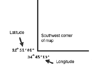
Latitude and longitude are also shown on maps in the corners. Latitude is
given to the left and right of the map: longitude is above and below it, as
shown in the diagram. On U. S. Geological Survey maps, latitude and
longitude are given in degrees, minutes (60 minutes = 1 degree) and seconds
(60 seconds = 1 minute), read , for example as, 45 o
34'56".
PROCEDURE:
- Discuss with students on how maps show relief,
even in two dimensions. Only topographic or shaded relief maps can show
you that the world is not flat. There are also relief maps, but they are
three dimensional. Maps help us in several ways including:
- To make a very large area look small and
understandable,
- As tools for planning (i.e. dams, highways,
urban development),
- To help us find our way in unfamiliar areas,
- Show us where major places are.
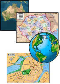
- Discuss different types of maps with the class. A
map is a representation of the Earths surface. A globe is also a type
of map. Show as many examples as you have including topographic, road,
political, and weather maps. Show them a physiographic relief map, to
show them that not all maps are two dimensional. You may also want to
discuss virtual maps that are in cars to help you when you are lost!
- Review the orientation information on a map with the students. Include
geographic orientation (north, south, east, and west). On almost all
maps, north is toward the top of the map. It is also shown by an arrow
in the maps legend. Discuss the other components of a maps legend.
Show them the Topographic map symbols.
- Give students the worksheet and then go over the
answers with the students.
ANSWERS:
- Road Map, a map that would have all the
states and major roads
- Globe, since a globe is the best
representation of distance
- Navigation Map, a map of the oceans usually
gives miles in nautical miles, especially used by shipping and Navy
- Topographic Map, elevation and how steep an
area is given
- Geologic Map, different colors usually tell
you the different types of rocks
- Legend