BACKGROUND:
A map is a picture or representation of the Earth's surface. Maps show
how things are related to each other by distance (both horizontal and
vertical), direction, and size. Maps are a way of showing many things about
a portion of the Earth's three dimensional surface on a flat piece of paper.
This two dimensional representation can be carried and transported easily. A
map is not a picture of the Earth's surface. Maps can show many things that
pictures cannot show.
Topographic maps contain accurate information about vertical distances,
or elevations, on the Earths surface. As discussed in the Pre Lab,
elevations are shown on topographic maps using contour lines. These are
imaginary lines of equal elevation. The 0 foot contour line is always
sea level. Contour lines are spaced at a regular contour interval, such as
25 feet.
Maps are smaller than the areas they portray: otherwise, they would be
useless. Imagine a map of your city that is city-sized!. Distances on maps
are thus smaller than the real distances they represent. The relationship
between 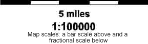 map distance and real distance is called a maps scale.
Topographic maps show two scales. A bar scale shows distances graphically.
Topographic maps also have a fractional scale. This appears on the map as a
ratio. This ratio tells how many real measurement units equal one of the
same unit on a map. In the example in the diagram, the fractional scale is
1:100000. This means than one inch on the map equals 100,000 inches in the
real world. This scale can be used with any measurement, such as inches,
centimeters, or feet. The larger this scale is, the more area a map covers.
For example, a map scale of 1:24000 covers a few miles: a map scale of
1:1000000 covers many states. map distance and real distance is called a maps scale.
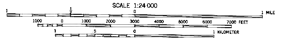
Topographic maps show two scales. A bar scale shows distances graphically.
Topographic maps also have a fractional scale. This appears on the map as a
ratio. This ratio tells how many real measurement units equal one of the
same unit on a map. In the example in the diagram, the fractional scale is
1:100000. This means than one inch on the map equals 100,000 inches in the
real world. This scale can be used with any measurement, such as inches,
centimeters, or feet. The larger this scale is, the more area a map covers.
For example, a map scale of 1:24000 covers a few miles: a map scale of
1:1000000 covers many states.
The details of these scales are more than most students can understand.
The important point for them to understand is that maps accurately show the
real world through mathematical ratios or scales.
PROCEDURE:
This lab can be customized to your local area if you have appropriate
topographic maps. You would have to create a new lab sheet, but it would be
worth the time. Also, the internet has more and more topographic maps
available. This may be a good lab to do with computers.
- Compare a topographic map with a road map. Explain that a topographic
map can show land features (landscape) and elevations (vertical
distances), while a road map just shows human-made features and
horizontal distances. You may wish to write a chart on the board,
comparing topographic and road maps on the board. Here are some
suggested differences:
|
TOPOGRAPHIC MAP |
ROAD MAP |
|
waterways
landforms
parks
forest
mountains
|
roads
buildings
boundaries
landmarks
street names
|
-
Go over the topographic symbols with students.
-
Give the students the 5 topographic maps or other maps you might be
using. We have enclosed copies of the topographic maps, but they are not
at the right scale. We highly suggest you purchase large maps for
students to use. Maps can be purchased through the U.S. Geological
Survey.
Have them compare and contrast the maps, and answer the questions on
their worksheets. Don't give them too many hints about how to answer the
questions. See if they recognize that although the topography on each of
the maps is different, the maps all have the same color and symbols.
This will be discussed in the post lab.
ANSWERS using the maps suggested:
1. Mt. Whitney
2. Blue Lake, CA
3. Laguna Beach, CA; Newark, CA, Joshua Tree South, CA, Blue Lake, CA
4. Newark (1:24,000); Bluelake, CA (1:24,000); Superstition Mountain, CA
(1:24,000); Laguna Beach, CA (1:24,000), Mount Whitney, CA 1:24,000
5. Laguna Beach, CA [Newark, CA shows San Francisco Bay]
6. Mt. Whitney, CA - 4416.9 meters, or 14494 ft [on Mt. Whitney, CA]
7. Mt. Whitney, CA
8. Newark, CA
9. Mt. Whitney, CA
10. Superstition Mountain, CA (the dotted blue lines mean a creek that
is dry most of the time)
11. Blue Lake, CA - the solid green shows forest
12. Laguna Beach, CA
13. Newark (1:24,000) flat, near San Francisco Bay; Bluelake, CA
(1:24,000) many trees, lots of creeks, hilly; Superstition Mtn., CA
(1:24,000) mountainous in the center, flat toward the north and south,
vegetation during wet times; Laguna Beach, CA (1:24,000) near ocean,
mountainous land, Mount Whitney, CA 1:62,500, very mountainous (highest
in continental United States)
|