BACKGROUND:
As described in the Pre Lab, there are three types of
plate boundaries. In some places, two plates move apart from each other
called a diverging plate boundary. Elsewhere two plate move together called
a converging plate boundary. Finally, a transform plate boundary occurs when
two plates can slide past each other horizontally.
Geologists use many types
of evidence to locate the boundaries between plates. Most of these
indicators are signs of stress, which develop as the two plates interact.
The clearest indicators are patterns in the locations of earthquakes and
volcanoes. From examining a map of earthquake and volcanic activity, it is
very apparent that these events do not occur randomly. Both tend to occur in
linear belts which mark the plate boundaries. Each type of plate boundary
has a somewhat different pattern of earthquakes and/or volcanoes. At
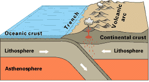
converging plate boundaries, two situations are possible. First, both
volcanoes and earthquakes form where one plate sinks under the other. This
process, called subduction, takes place because one plate is denser than the
other. The denser plate, which invariably has oceanic crust on its top, does
the sinking. Earthquakes occur along this plate as it sinks and is pulled
into the upper mantle. Second, only earthquakes occur when two plates
collide (obduct), building a mountain range. This situation is common when
two plates with continental crust on top converge. The density of
continental crust is too low for it to subduct; it is like wood floating on
water. Instead, the two plates have a head on collision - building a
mountain range. The Himalaya Mountains in Asia formed this way, from a
collision between the Indian and Asian Plates. At transform plate
boundaries, the two plates slide by each other. This generates little
volcanic activity (there is no "gap" between the plates) or
mountain building. Earthquakes, however, are common. At diverging
plate boundaries, earthquakes occurs as the plates pull away from each
other. Volcanoes also form between the plates, as magma rises upward from
the underlying mantle. We rarely see these volcanoes erupt, as most of them
are on the ocean floor. Transform plate boundaries commonly have only
earthquakes.
In this lab, students will try to recognize plate
boundaries using the locations of earthquake epicenters. Their work will be
based on a map produced by the Earthquake Data Service of the National
Oceanic and Atmospheric Agency, which shows the locations (epicenters) of
all earthquakes of magnitude 4.5 or greater on the Richter scale for the
years 1963 - 1974. The students will also color, cut out, and fold the map
into an icosahedron (24-sided) globe.
PROCEDURE:
- Before lab, print copies of the icosahedron map for each student. We
have provided a color version of this map below. It can also be printed
in black and white in the larger format.
- Instruct the students to trace the plate boundaries on the map. Tell
them to carefully think about where the plate boundaries are located,
and not to just draw a zig zag puzzle. Remind the students to use the
large world earthquake map (if available) for reference. Have the
students color the continents to observe where the plates are located.
When they have completed coloring the map and tracing the plate
boundaries, have the students cut the map out and put it together. Make
sure that they cut along the outside border, including the tabs. The
globe assembles best if it is folded along the black lines before being
glued.
- Use drawings or other the presentation images from the Pre Lab to show
converging, diverging, and transform fault plate movements. Stress that
one kind of plate movement in an area means that plates in adjacent
areas are affected by that movement.
- Review the questions on the lab sheet. Discuss why students might have
different results. Compare their Lab results with their Pre Lab
findings. Tell the students that geologists sometimes debate about how
many plates there really are!
ANSWERS:
- Will vary from student to student.
- Yes, there are many problem areas. Hawaii, Yellowstone, Africa,
Arctic, Antarctica, Mediterranean area. Students may find more. Ask
them why they called it a problem.
- Africa, Antarctica, Eurasian continent, many other areas depending
on how detailed the students get. Conclusion is that earthquakes can
occur just about anywhere.
- On the west coast (including Alaska) of the United States you have
the North American Plate meeting the Pacific plate.
|