|
LOCATION
Mission Creek is located in Fremont, California, north of the Laguna
Creek Watershed. It starts at nearly 1 km north-northeast of Mission Peak,
on the north side of Mill Creek Rd and runs in an overall west direction
till Lake Elizabeth. At Lake Elizabeth it is diverted to the south and
feeds into Laguna creek, which flows into San Francisco Bay. Mission Creek
has a total stretch of approximately 12.25 km.
GEOLOGIC MAP
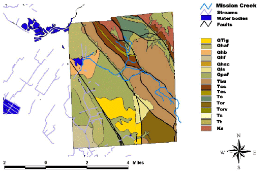
Mission Creek dissects 5 geologic units: the Briones Formation (Miocene),
the Tice Shale (Miocene), the chert and siliceous shale member of the Claremont
Formation (Miocene), older alluvial fan deposits (Pleistocene) and flood
basin deposits (Holocene). Erosion occurs predominantly in the hills where
the Briones and Claremont Formations and the Tice shale are exposed but
also in the older alluvial fan deposits, as it can be observed at the outlet
of a closed channel under Palm Avenue in the school yard of Mission San
Jose High School. Sedimentation occurs further down the creek in the flood
plain deposits and in Lake Elizabeth. Lake Elizabeth is an artificial lake
that over the last 30 years has been silting up and accumulated up to 2
ft of sediments (Environmental Science Association, 1993).
UNNAMED (Holocene) (QTig, Qhaf, Qhb, Qhf, Qhsc,
Qis)
Organic-rich clay to very fine silty-clay deposits
occupying the lowest topographic position either between the Holocene levee
deposits or Holocene flood plain deposits.
UNNAMED (Pleistocene) (Qpaf)
Tan to reddish brown, dense, gravely and clayey
sand or clayey gravel that grades upward to sandy clay.
BRIONES FORMATION (late Miocene) (Tbu)
The basal part of this formation consists of distinctly bedded, gray
to white fine-grained sandstone and siltstone. Bedding is parallel and
cross-beds are not evident. Sandstone beds are as thin as 5 to 10 cm with
2 to 10 cm thick shaley interbeds. These are interbedded with massive fine-grained
sandstone beds as much as 5 m thick. The middle part of the formation (shell
beds) consists of indistinctly-bedded, white, fine to coarse-grained sandstone,
conglomeratic sandstone, and massive, shell-hash conglomerate. Shell-hash
conglomerate is made up of interlocking mollusk and barnacle shells and
shell fragments in a white calcareous sandstone matrix. Pebble and cobble
conglomerate beds are present in a few places. Conglomeratic clasts include
black chert, red chert, quartzite, andesite, argillite, siltstone, basalt,
felsic tuff, and vein quartz. The shell beds and conglomerates are hard
and resistant and form prominent ledges, ridges and peaks such as Mission
Peak. The upper portion of the formation consists of distinctly indistinctly-bedded,
massive to cross-bedded, fine to coarse-grained white sandstone. Sand grains
are predominantly quartz and feldspar. The sandstone has in many places
a distinctive peppered appearance caused by small black grains (chert according
to Hall, 1958). The Briones formation as a whole weathers to a distinctive
orange color. It is at least 1150 m thick, although the base and the top
are not exposed in continuous sequence. Trask assigned the Briones Formation
to the late Miocene based on a large fauna of invertebrates collected from
localities throughout the East Bay area, including one locality in the
Northeast corner of the Niles Quadrangle (near locality #19 on table 1).
Hall (1958) also assigned the Briones formation to the late Miocene based
on invertebrates and the Mohnian stage of Kleinpell (1938) based on Foraminifera
collected in the Niles quadrangle and adjacent quadrangles (including locality
#19 on table 1). Most
fossil localities in the Briones formation in the Niles Quadrangle lies
east of the Calaveras fault, but Hal (1958) and Crittenden (1951) have
both identified several late Miocene invertebrate fossils from the formation
west of the Calaveras fault in the area south of the Niles quadrangle.
CLAREMONT FORMATION (middle to late Miocene)
(Tcc, Tcs)
Chert occurs as distinct, massive, gray beds as much as 10 cm thick
with thin (about 1 to 2 mm) shale partings. Chert forms about 30 % of the
member in the Niles quadrangle. Siliceous shale is dark brown to gray,
finely laminated, with grains ranging from clay to silt size. Some of the
shale contains abundant poorly preserved Foraminifera and fish scales.
This member also contains prominent interbedded lenses of massive, tan,
foraminifer-bearing dolomite as much as 1 m in length, that weathers to
a distinctive yellow orange, similar to those found in the Tice shale and
Oursan sandstone. The Claremont chert and shale member is similar to the
Tice shale, but it is distinguished by the presence of chert and more siliceous
shale.
OURSAN SANDSTONE (To)
Distinctly to indistinctly - bedded black mudstone,
and Foraminifera - bearing, brown to tan siltstone and fine - grained sandstone.
In places these rocks have a large amount of secondary calcite. The
Oursan is distinguished from the Briones and Claremont Formations by its
darker color, finer grain size, and presence of Foraminifera in siltstone,
sandstone and dolomite. In this area it is 300 to 1000 meters thick.
ORINDA FORMATION (Tor,Torv)
Distinctly to indistinctly bedded pebble to boulder
conglomerate, conglomeratic sandstone, and coarse to medium - grained lithic
sandstone. At least 1500 meters thick in this area, although the
base and top are not exposed in continuous space. It is easily distinguished
from other conglomerates in the area by the red and green color.
SOBRANTE FORMATION (Ts)
White, fine to medium grained quartz sandstone.
Occurs in discontinuous outcrops below the base of the Claremont Formation
in the eastern part of the quadrangle, nowhere more than 120 meters thick,
in fault contact with underlying Cretaceous rocks.
TICE SHALE (middle Miocene) (Tt)
Distinctly bedded, dark brown, gray and tan, siltstone, mudstone and
siliceous shale. Tice shale weathers in place to a reddish brown color,
and in places contains abundant fish scales. The shale also contains numerous
lenses of massive, tan dolomite, as much as 2 m in length that weathers
to a characteristic bright orange color. Many of the dolomite lenses contain
Foraminifera that are evident on weathered surfaces of the rock. Tice shale
has a maximum thickness of 290 m in this area. Tice shale is similar to
shale in the Claremont formation in the Niles Quadrangle, but lacks the
chert beds characteristic of the Claremont. Kleinpell (1938) dated the
Tice shale as correlative with the early part of the Mohnian stage (middle
Miocene) based on Foraminifera found in the Concord area about 40 km to
the north of the Niles Quadrangle. Hall (1958) considered the Tice shale
in the Niles Quadrangle to be middle Miocene based on stratigraphic relationships
with surrounding strata and lithologic similarity to shales in the Concord
area.
UNNAMED (Cretaceous)
Distinctly bedded gray to white, well lithified, massive to cross bedded,
micaceous, coarse to fine grained sandstone, siltstone and shale. Sandstone
varies from granitic (quartz, feldspar, and biotite grains) to lithic wacke
(grains of mica, clay, quartz, feldspar and lithic fragments). Sandstone
and shale beds are interleaved and range from several cm to several meters
thick. In some places the shale contains small (10 cm) to large (1-2 m)
limestone concretions. Poorly preserved Foraminifera are present in many
shale outcrops, and plant debris is common. Sandstone tends to form outcrops
on the ridges and uplands, and prominent resistant outcrops in canyons,
whereas the shale interbeds are largely visible only in canyons. |