BACKGROUND:
The rotation of the Earth
affects the movement of the atmosphere. The Coriolis motion plays
a similar role in the atmosphere as it does in the oceans. Air is
much more fluid than water and can move more rapidly. The atmosphere
also has different factors affecting it, such as temperature differences,
topography, and location (i.e., over land or water). A basic cause of wind
movement in the atmosphere is the difference of temperature. Warm
air rises, which causes movement. Air can move horizontally from high to
low pressure areas. Moving air already in motion is deflected
by the Coriolis Effect. The Coriolis Effect deflects particles in
the northern hemisphere to the right, and to the left in the southern hemisphere.
These three basic factors, Coriolis motion, pressure differences, and differences
in temperature, create the patterns that are shown in the students' lab
sheet, “World Wide Air Movement.”
We can learn about the movement
of particles in the atmosphere, especially the troposphere (about 0-17
km) and the stratosphere (about 17-48 km) by charting particle movements.
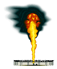
Sometimes a natural event, like a volcano explosion can help determine
the wind patterns. Mt. St. Helens is a volcano that violently erupted
in 1980. Ash from the explosion was transported to very far distances.
Maps of the direction of movements provided valuable information on the
wind patterns in the troposphere and stratosphere. Collecting
data from one event and then using that data to predict the outcome of
another event is an experimental tool in science. Meteorologists
use this type of data collection to help them predict future events.
PROCEDURE:
- Look at the Mt. St. Helen’s maps and answer
the appropriate questions on the lab sheet. Go over the distribution
maps with the students before they answer the questions. Can the ash flow
be connected with wind direction? Get the students to compare the different
maps. The air currents played a direct role in transporting ash over thousands
of miles. Ash from volcanoes can be helpful and harmful. The
ash contains minerals that when incorporated in soil, increases plant growth.
However, the fine particles can get into lungs and cause respiratory damage.
- After the students look
at the Mt. St. Helens and air flow maps, have them trace the direction
that fallout from a "Nuclear" disaster would travel. The knowledge
they learned about the volcano eruption should help them predict what would
happen during an event that would become airborne. Talk about the importance
of the atmosphere and how it moves fine-grained particles. Students
need to carefully look at the direction of the wind patterns. You
may want to add other locations on the map.
- Students need to look at
the ash data and then make an inference of what might happen in a separate
event. Students should think about whether nuclear fallout is similar
to ash. Some of the students may even ask what type of nuclear disaster.
Do you mean a warhead or a nuclear plant that fails? Encourage your
students to look at the similarities, but also the differences.
Understanding the two models can help make a more accurate prediction.
This might lead into a discussion about effects of nuclear war or other
pollution that can be carried by the atmosphere. So be prepared!