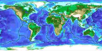
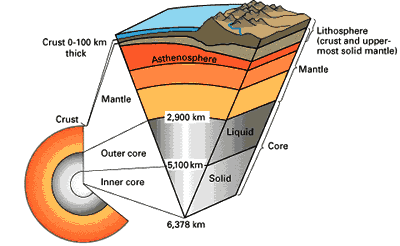
According to the theory of plate tectonics, the
Earth's crust and upper mantle are broken into moving plates of
"lithosphere." The Earth has two types of crust. Continental crust
underlies much of the Earths land surface. The ocean floors are underlain
by oceanic crust. These material have different compositions; the
continental crust is like the igneous rock granite, and the oceanic crust is
like basalt, another igneous rock.
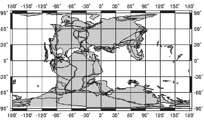
 Students
and many adults often equate the geographic continents, i.e., land, with the
plates. This is incorrect. The Earths various units of continental crust
are actually embedded into plates. You may wish to explain this to your
students by saying that the continental crust "ride on the back"
of a plate. Moreover, continental and oceanic crust are often part of the
same plate. For example, the North American plate has continental crust
(essentially the land area of North America) at its core and is surrounded
on most sides by oceanic crust.
Students
and many adults often equate the geographic continents, i.e., land, with the
plates. This is incorrect. The Earths various units of continental crust
are actually embedded into plates. You may wish to explain this to your
students by saying that the continental crust "ride on the back"
of a plate. Moreover, continental and oceanic crust are often part of the
same plate. For example, the North American plate has continental crust
(essentially the land area of North America) at its core and is surrounded
on most sides by oceanic crust.
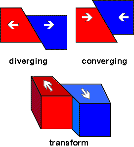 As
they move, plates interact at their edges or boundaries. There are three
basic directions or types of boundary interactions. In some places, two
plates move apart from each other; this is called a diverging plate
boundary. Elsewhere two plate move together, which is called a converging
plate boundary. Finally plates can also slide past each other horizontally.
This is called a transform plate boundary. Volcanoes and earthquakes help
define the boundaries between the plates. Volcanoes form mostly at
converging and diverging plate boundaries, where much magma is generated.
Earthquakes occur at all three types of boundaries. Because the plates are
rigid, they tend to stick together, even though they are constantly moving.
This builds up stress in the rocks at the plate boundary. When the strength
of the rocks is exceeded, they move rapidly, "catching up" with
the rest of the plates. We feel this release of energy as an earthquake.
As
they move, plates interact at their edges or boundaries. There are three
basic directions or types of boundary interactions. In some places, two
plates move apart from each other; this is called a diverging plate
boundary. Elsewhere two plate move together, which is called a converging
plate boundary. Finally plates can also slide past each other horizontally.
This is called a transform plate boundary. Volcanoes and earthquakes help
define the boundaries between the plates. Volcanoes form mostly at
converging and diverging plate boundaries, where much magma is generated.
Earthquakes occur at all three types of boundaries. Because the plates are
rigid, they tend to stick together, even though they are constantly moving.
This builds up stress in the rocks at the plate boundary. When the strength
of the rocks is exceeded, they move rapidly, "catching up" with
the rest of the plates. We feel this release of energy as an earthquake.
One of the first observations used to suggest that the
outer portion of the Earth is mobile is the fit of the continents,
particularly the west coast of Africa against the east coast of South
America. This observation predates plate tectonics. It was first noticed in
the 18th century, and most recently proposed by a German
scientist, Alfred Wegener in 1912. Wegener called his theory
"continental drift", referring to the apparent movement of
continents alone. However, "continental drift" is a only
historical term. We now know it is not the continents that move, but the
plates, in which the continents are embedded. South America and Africa were
once together, but were split apart by the formation of a diverging plate
boundary. This is also confirmed by matches between the rocks and fossils of
the two continents. The two continents are still moving away from each other
today.
This exercise looks at the continents of North
America, South America, Africa, Antarctic, and Australia, and how they have
moved over the last 200 million years. At that time, these five continents
were all part of a single large super continent, called Pangaea. Starting
about 180 million years ago, Pangaea began to break up; new diverging plate
boundaries formed within it. This eventually created the continents we see
today. In this exercise, the students will reconstruct Pangaea. They will
use the fit of the continental crust to put Pangaea back together.
PROCEDURE:
- Remind the students of the information they learned in the Pre Lab.
Explain again that the plates are moving, due to convection and gravity.
Explain that this movement causes stress within the plates, which
generates earthquakes and volcanoes. You may want to show students a map
of the plates.
- Review the composition of the plates with the class. Make sure the
students understand that the continents make up the non-oceanic part of
the crust. Discuss with them that the edges of the continents look as if
they may have fit together at one time.
- Have the students label, color, cut out, and fit the continents
together. The lines and numbers make this puzzle a little easier. You
may want your students to work in pairs. Matching up the continents is
not as easy as it looks.
- Once the students have placed the continents together have them move
the pieces apart very slowly. They are to move the pieces until they
reach their present positions.
- Ask students if they think this movement could have happened. Let them
come up with stories about why it took place. Remind them of convection
and the moving of the plates. This is a difficult concept to get across
to the students.