|
EQUATIONS OF SCIENCE
|
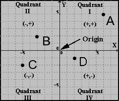
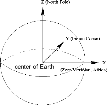
Cartesian coordinates help locate a point by using a reading from the x axis (abscissa) and one from the y axis (ordinate). By convention the abscissa is written first, separated by a comma (x,.y). The origin is the center at (0,0). This system allows that any point is associated with an ordered pair of real numbers. The quadrants are divided into 4 parts and are numbered as Quadrant I, II, III, and IV. For instance, in the graph to the left, point A is located by finding its x and y axis. Since it is in the first quadrant it is all positive (6,5). However, Point B is a negative x axis so its position is (-3,2). Point C is all negative (-5,-2) and Point D is (4,-4). The Cartesian coordinate system is used to determine each point in either a two dimension or 3 dimensional systems. The coordinates are defined by the x axis and y axis for two dimensional systems and the addition of the z axis for three dimensional systems. Global Position System (GPS) uses the Cartesian Coordinate System to find reference points to compare on a world-wide grid. On the figure to the left, you would use the center of the Earth as (0, 0). The z axis is pointing north; the Y points to the Indian Ocean and the X axis points to Africa. Once you develop formulas for distance and movement you can then track yourself on a grid. Almost like the fly on Descartes ceiling. The applications of using the power of a Cartesian Coordinate System is limitless. You can create graphs at any angle on three dimensional objects and look at a plane surface. As researchers collect data to try and solve problems. Science and math act as one!
|