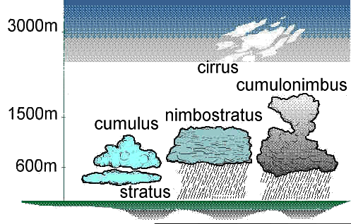
 There are four
major groupings of clouds based on their position. High-level clouds
form above 20,000 feet (6,000 meters) and since the temperatures are so
cold at such high elevations, these clouds are primarily composed of ice
crystals. High-level clouds are typically thin, wispy, and white in
appearance. Cloud types include cirrus and cirrostratus. There are four
major groupings of clouds based on their position. High-level clouds
form above 20,000 feet (6,000 meters) and since the temperatures are so
cold at such high elevations, these clouds are primarily composed of ice
crystals. High-level clouds are typically thin, wispy, and white in
appearance. Cloud types include cirrus and cirrostratus.
Mid level clouds typically appear between 6,500 to
20,000 feet (2,000 to 6,000 meters). Because of their lower altitudes,
they are composed primarily of water droplets, however, they can also be
composed of ice crystals when temperatures are cold enough. Cloud types
include altocumulus and altostratus.
Low clouds are composed of water droplets since
their bases generally lie below 6,500 feet (2,000 meters). However, when
temperatures are cold enough, these clouds may also contain ice
particles and snow. Cloud types include nimbostratus and stratocumulus.
Vertically Developed Clouds are created commonly
through either thermal convection or frontal lifting. These clouds can
grow to heights in excess of 39,000 feet (12,000 meters). Cloud types
include fair weather cumulus and cumulonimbus.
|