|
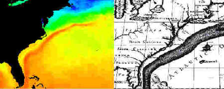
Currents were known to most ancient mariners. Benjamin
Franklin in the late 1700's first charted the Gulf Stream Current in the
North Atlantic using temperature. His maps helped many ships to get to
England faster. The Earths rotation explains the general surface
circulation. As the Earth spins on its axis, the equator moves faster
than the poles. As you go from the equator you are traveling 1600 km
(1000 miles) per hour, while at the poles you are standing still. In the
northern hemisphere the currents are deflected to the right, or
clockwise. In the southern hemisphere the surface currents are deflected
to the left or counterclockwise. This especially holds true in the
Atlantic and Pacific because the north and southern portions are open.
The Indian Ocean, on the other hand does not have a northern hemisphere
equivalent. There is only a large land mass (Asia). This will become an
important point when we look at weather patterns.
This deflection is referred to as the Coriolis Effect, and is
the overprint of other factors that will make motion in the oceans.
|
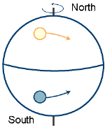
Coriolis effect
|