| What is a Geographic Information
System?
The program you used at the museum is an
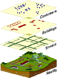
example of a geographic information system, or GIS. A GIS is a type of
computer software. The basis for this software is a computerized map.
Like a regular paper map, a GIS map shows where things are located. A
GIS, however, is much more than a map. It also contains a database of
information about the things on the map, such as what was displayed in
each room of the museum. In addition, the GIS contains software that
analyzes the database and map information to find connections between
them. Searching for gemstone displays in the museum is an example of a
GIS analysis. To answer your question, the software examined the
database and map, and gave you the location of the gemstone exhibit.
There is no fixed information to go with the map in a GIS. Some GIS
show where power lines run, others show the roads, while others show
schools. |
|