 EARTHQUAKES
AND ECOLOGY
EARTHQUAKES
AND ECOLOGYLesson Plan
Tule Ponds at Tyson Lagoon
EARTHQUAKES
AND ECOLOGY
Lesson Plan
Tule Ponds at Tyson Lagoon
OBJECTIVES:
1. Discovering
that Tyson Lagoon is a sag pond created by the Hayward Fault.
2. Look at evidence of four major
earthquakes in the last 500 years.
3. Comparing a local topographic
and geologic map of the area.
4. Discussing the path of drainage
into Tule Ponds and Tyson Lagoon and how it shapes the landscape.
5.
Observing the overall ecosystem in an aquatic and riparian environment.
6.
Explore how the area is being restored to increase habitat for birds,
amphibians, reptiles, and mammals.
VOCABULARY:
·
contour
lines - equal lines of
elevation
·
ecosystem
- biological community
together with its environment, functioning as a unit
·
faults
– fracture that can be traced by topographic and geological features, a break
·
formation
– rocks that have been deposited in a similar environment about the same time
·
geologic
map – map that shows where different types of rocks are located
·
sediments
– small particles of rocks
·
topographic
map - a map that shows
relief on land
BACKGROUND:
Topographic maps show a 3 dimensional world
in 2 dimensions by using contour lines. Many people have trouble reading
these maps, because they have mountains and valleys are represented with concentric
circles and lines. Many hikers use topographic maps, especially in areas where
there are no roads with signs. Geologists depend on topographic maps to record
the types of rocks. Engineers use topographic maps when they are planning roads,
buildings, or other human–made structures. Imagine designing a city without
considering where hills and valleys are located!
A geologic map is a map of the different
types of rocks that are on the surface of the Earth. By mapping different rock
types, geologists can determine the relationships between different rock
formations which can then be used to find mineral resources, oil, and gravel
deposits.
Earthquakes are caused by the sudden movement
and fracturing of rock masses along pre-existing faults. A fault is a broken
surface within the Earth’s crust.
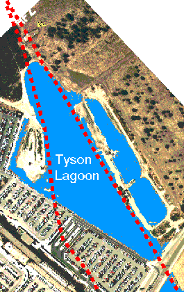 Tyson
Lagoon has been a site of fresh water for at least the last 3700 years (Lienkaemper,
et al, 2002). This sag pond outlines the trace of the Hayward fault zone in this
area. Looking at brittle deformation and liquefaction features in trenches just
north of this area, Williams (1993) concluded there may have been 6-8 large
earthquakes during the last 2000 years. Lienkaemper, et al, with new data
concluded that since late 1300’s there were probably 4 large earthquakes (of
magnitude 6.8-7.0) In trenches in the South Pond they found evidence of the 1868
earthquake. The earthquake destroyed most of the Mission Adobe structure and
devastated the homes of many of the residents. Using detailed stratigraphy and
carbon dating they arrived at dates of 1730, 1630, and 1470 (±90 years) for the
other earthquake occurrences.
Tyson
Lagoon has been a site of fresh water for at least the last 3700 years (Lienkaemper,
et al, 2002). This sag pond outlines the trace of the Hayward fault zone in this
area. Looking at brittle deformation and liquefaction features in trenches just
north of this area, Williams (1993) concluded there may have been 6-8 large
earthquakes during the last 2000 years. Lienkaemper, et al, with new data
concluded that since late 1300’s there were probably 4 large earthquakes (of
magnitude 6.8-7.0) In trenches in the South Pond they found evidence of the 1868
earthquake. The earthquake destroyed most of the Mission Adobe structure and
devastated the homes of many of the residents. Using detailed stratigraphy and
carbon dating they arrived at dates of 1730, 1630, and 1470 (±90 years) for the
other earthquake occurrences.
Detailed trenching in the south pond of Tyson
Lagoon by the U.S. Geological Survey has identified other earthquakes that
occurred in the past. They use data derived from trench logs, radiocarbon,
pollen, and detailed sedimentolgical data. The trenching has exposed typical
pond sediments, including well-bedded deposits of silty clay, interbedded with
organic layers including shell hashes, and slightly coarser, less organic silts
to sandy silts. The composition and structure of the deposits indicate a rapidly
subsiding, shallow aquatic environment that was subject to seasonal drying.
Evidence of creeping along the fault has been calculated with an average slip
rate of 9± 2mm/yr (Leinkaemper and Borchardt, 1996)
PROCEDURE:
1. Explain what a topographic map is,
including contour lines. Locate
region on the topographic map of the region.
Instruct students to locate Tule Ponds at Tyson Lagoon, Lake Elizabeth,
the railroad, Vallejo Mill School, Morrison Canyon, Shinn House, Alameda Creek,
Hetch Hetchy Aqueduct, Benchmark 60, Mowry Well
2. Explain
what a geologic map is. Show them
the rocks that come from the different units.
Instruct students to color the maps so it is easier to identify the
different regions.
3. Look
at the fault and discuss the relationship with Tule Ponds and Tyson Lagoon
4. Go
on a walk of the facility pointing out the evidence for fault in the area,
especially the sag pond and offset.
5. Discuss
with students how faults in this area create wetland environments that are
excellent habitat for many species that have been dislocated due to urban
sprawl.
FOR MORE LESSONS:
http://msnucleus.org/membership/html/k-6/pt/earthquakes/6/pte6_3a.html
http://msnucleus.org/membership/html/k-6/pt/hazards/6/pth6_2a.html
http://msnucleus.org/membership/html/k-6/lc/ntenvn/6/lcne6_1a.html