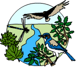
MISSION  CREEK
TOPOGRAPHY AND GEOGRAPHY
(pdf version)

These lesson plans have students observe different portions of topographic maps and try to determine the flow of Mission Creek and all its tributaries. Topographic maps show a 3 dimensional world in 2 dimensions by using contour lines, or equal lines of elevation.

 A watershed or drainage basin refers to a system controlled by topography that defines how water will flow. You refer to a watershed by the largest body of water that the creeks, rivers or streams feed into. For example, all creeks that flow in the San Francisco Bay are part of the San Francisco Watershed. However, there are many smaller watersheds within this area depending on flow patterns.  The Mission Creek Watershed would represent all tributaries that flow into Mission Creek.  When Mission Creek divides at Paseo Padre is  the end of the Mission Creek Watershed.

 A watershed has an orderly flow pattern. The pattern is dendritic or branching, as it flows from the headwaters to a larger body of water. When one stream flows into a larger stream or river they are called tributaries. The smallest channels in a watershed with no tributaries are called first order streams. A second order stream is when two first order streams join. If you look at the stream order diagram, you can see the creation of a fifth order stream channel. Fifth to sixth order streams are usually larger rivers, while first and second order are often small, steep, or intermittent.

Defining the Mission Creek Watershed

Recommended Grades:  Secondary

OBJECTIVES

  • Define a watershed.

  • Trace and locate places on topographic maps.

MATERIALS

  • Copies of 2 sections from Niles Quadrangle  and one from LaCosta Quadrangle Topographic Map

  • Student Sheet “Defining the Mission Creek Watershed”

BACKGROUND

What is a watershed? Almost all the area of a watershed is land, not water.  By definition a watershed is the land area from which water, sediment, and dissolved material drain to a common watercourse or body of water.  Did you know that you live on a watershed?  We are fortunate living in Fremont to be able to access and study the Laguna Creek watershed, which is actually part of the larger Coyote Watershed, which includes southern Fremont and parts of Santa Clara County (delineated by U.S. Geological Survey).  When studying watersheds, it is important to understand all of the factors which effect the watershed system.  Factors include climate, physical features, soil, geology and vegetative cover.

In this unit, students will study and trace the path of Mission Creek and locate other places on a section of the Niles and LaCosta Quadrangles from the U.S. Geological Survey.

PROCEDURE

Students should use the sections copied from  U.S. Geological Survey 7.5 minute quadrangles and answer the questions on the worksheet.  If students are unfamiliar with the symbols used on the map, please refer to our lesson online on “Map Reading” and “Maps as a Tool.”  You can find them by using the following url:  http://msnucleus.org/membership/html/jh/earth/index.html

ANSWERS:

 2.  a) type of rocks; b) velocity of water; c) vegetation; d) topography
 6.  A benchmark is a measured elevation
 9. The contours are “pointing” in a different direction
10. flow of water through a human made channel
12.  holds water, but geological a sag pond caused by faults
13.  2517 ft
16.  east
19.  The friction of the fault causes heated water, hence warm springs

Defining the Mission Creek Watershed

QUESTIONS

1. Describe a watershed in your own words. 

2.  Give two examples of how factors can affect a watershed along its course.

3.  On each map put an arrow that points to North.

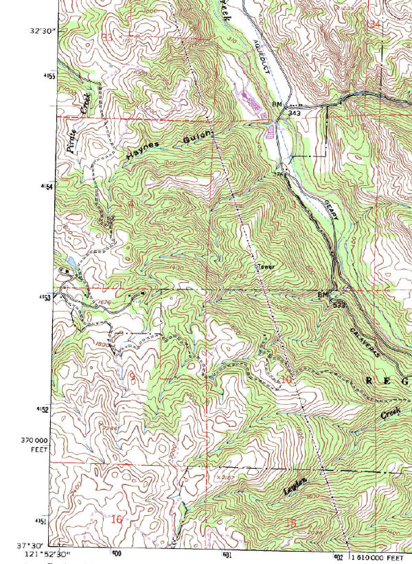
La Costa Quadrangle Section A.

4.  In the southwest corner find Mt. Allison and label it.  (hint: 2286’)

5.  Draw the trace of the Mission Creek headwater.  Remember this continues onto the Niles Quadrangle.

6.  Circle Bench Mark (BM) 533.  What is a benchmark?

7.  Circle the area of Haynes Gulch.  What is a gulch and how do you know from the topography that this is a Gulch? (Hint:  look at the contour lines.)

8.  Draw a line on the trace of high power lines.  (Hint:  find the word “tower.”

9.  Circle Leyden Creek.  Is the water flowing in the same direction as Mission Creek or the opposite direction?  How do you know?

10.  Trace the line of the “Aqueduct.”  What is an aqueduct?

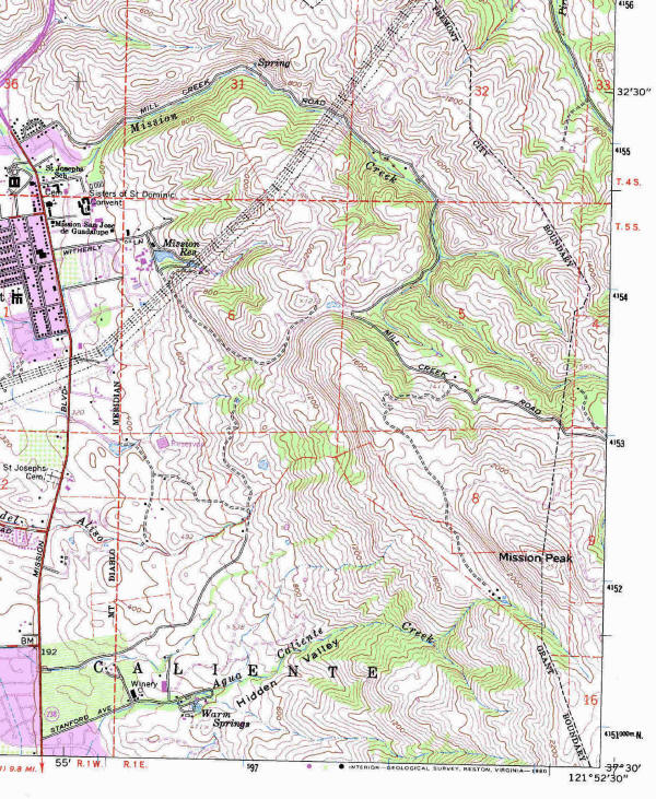
Niles Quadrangle Section B.

11.  Trace Mission Creek (hint: parallels Mill Creek Road in some places) to St. Joseph’s School, near Mission Blvd.

12.  Circle Mission Reservoir.  What is this feature?

13.  Circle Mission Peak.  What is the altitude of Mission Peak?

14.  Trace Aqua Caliente Creek.  Is it flowing into Mission Creek?  How do you know?

15.  Trace the electricity lines.  This power comes from generators near Yosemite.  These lines help move the electricity to the city.

16.  Is Mission Creek east or west of Mission Peak?

17.  Circle Benchmark 192.

18.  Trace the line that shows the city limits of Fremont.

19.  Circle Warm Springs.  Trace Aqua Caliente Creek.  This area has warm water.  Why?

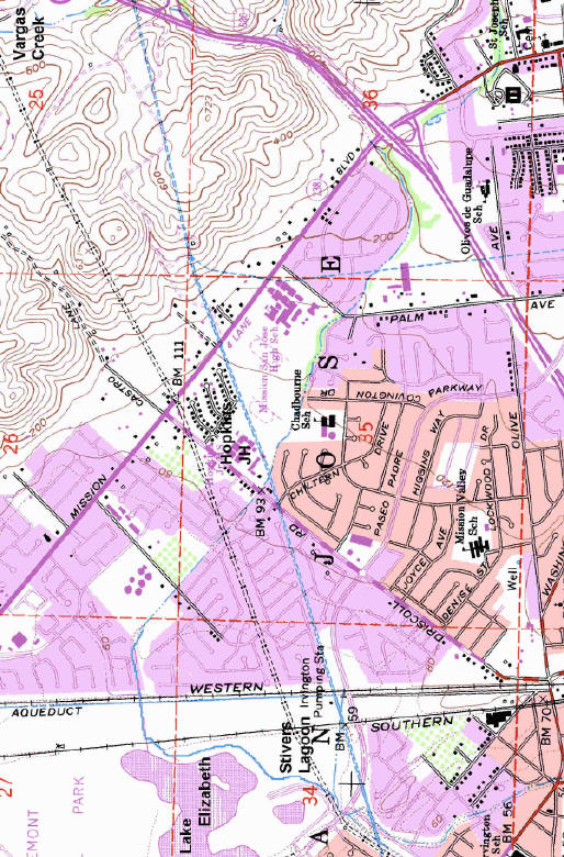
Niles Quadrangle Section C.

20.  Circle Stivers Lagoon and Lake Elizabeth.

21.  Trace Mission Creek to Stivers Lagoon.  Near Stivers it splits into 2 Creeks, Irvington and Laguna Creek.  Trace the split into the two creeks.

22.  Trace Vargas Creek.  Where does it meet Mission Creek?

23.  Circle Hopkins Junior High, Chadbourne Elementary, and Mission San Jose High School. 

24.  Gomes Elementary School is not written on the map but if you continue Mission Creek toward Lake Elizabeth you will see a large open area.  Label that Gomes Elementary School.

25.   Circle the Irvington Pumping Station.  Trace a line of the double dashed lines.  This is the trace of Hetch Hetchy water line that brings water from Yosemite area to San Francisco.  Fremont uses some of this water in their drinking supply.

26.  Circle Benchmark 70 and 93. 

27.  Trace the high voltage electricity lines (hint:  double dashed lines with dots).


La Costa Quadrangle Section A (north is on top)


Niles Quadrangle Section B
(north is on top)


Niles Quadrangle Section C  (north is to left)

Mission Creek Home Page