|
|
|
||
 OBJECTIVE
VOCABULARY:
Weather fronts (cartoon)
https://www.youtube.com/watch?v=tkK4_F0VKhM
Play Why Do Tornados Hate America
https://www.youtube.com/watch?v=0yiZveJAEp4 BACKGROUND:
You may want to discuss that warm air causes low pressure areas and that cold air causes high pressure areas. Generally a high pressure area moves toward a low pressure area, When the two air masses meet, they will form a FRONT, which will cause weather changes. Another term for a low pressure center is
called a cyclone and for high pressure area it can be called anticyclones. The
pressure decreases from the outside toward the center in a cyclone. In an
anticyclone the pressure increases from the outside toward the center. Winds
blow from high pressure to low pressure and are deflected to the right or left
by the earth's rotation. This deflection is similar to the deflection in the
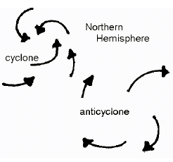
oceans. In the Northern Hemisphere the result is that winds blow in and
counterclockwise around a low and out and clockwise around a high as shown on
the diagram on the right. Local winds may "adjust" the situation. Local winds may be classified as slope winds, coast winds and mountain winds. Slope winds represent the slow drainage into the valleys of air which have been chilled by contact with the cool ground. Sea breezes are caused by land becoming considerably warmer than the sea. The breeze reaches its maximum strength in the early afternoon and usually persists into the evening before dying away. Mountain winds are caused when a "funnel" is produced by the topography of the mountain sometimes causing a very persistent wind for days. The underlying cause of winds is the unequal heating of the Earth's surface and the fact that the Earth rotates. But the amount of heat varies considerably, and there are many other factors. This is the reason why weather persons do not have a good record for predicting and forecasting the weather. It’s a hard job! PROCEDURE:
Last time we talked about air pressure.
Today we are going to talk about why we have differences in air
pressure in nature, about large air masses that have the same pressure and
humidity and how weather happens at fronts, regions were
air masses of different pressures
interact. Activity 1: Wind creation.
1.
Ask” Is there air pressure all around us?”
Yes (this is review from last time)
2.
Differences in air pressure causes
wind. Wind is caused by air
moving from high pressure zone to a low pressure zone.
3.
Show empty balloon. Is there
any air in it? (not much but
some). Is there any air
moving out? (no)
4.
Blow up balloon. Ask is there
any difference in pressure inside the balloon and outside?
(yes, higher pressure air inside balloon).
5.
Hold on to your balloon but allow air to escape onto something so students
can see the effect of the wind.
What is happening?
(High pressure air is moving to low pressure).
Once the pressure is equalized, the “wind” stops.
6.
Students blow up balloon.
7.
Have them hold the balloon and try to let the air out WITHOUT LETTING GO
OF THE BALLOON. They should
try to feel the air move on their other hand.
That is wind. What is
causing it? Air moving from
high pressure to low pressure.
Air always moves from high pressure to low pressure.
Once the pressure is equal the “wind” stops.
If they let the balloon go, the
balloon will move “forward” but that is due to the air rushing out in the
opposite direction.
8.
They should put their balloon in a baggie with their name on it to take
home. Should give them to the
teacher to keep until the end of the day.
ACTIVITY: Air Masses and
weather fronts
1.
So how do we get high and low air pressure in nature (without someone
blowing up a giant balloon). We
get differences in pressure due to unequal heating of earth’s surface.
2.
Watch video about air masses and fronts
https://www.youtube.com/watch?v=tkK4_F0VKhM
3.
Pass out worksheet and placemats. Students should look at the worksheet
and determine the type of stable air masses found in North America.
ANSWERS:
4.
Have the students look at the placemats to see which states are influenced
by what kind of air masses.
5.
Ask students about the weather patterns that occurs at the boundaries of
the air masses Usually they are very unstable and cause severe weather
patterns, except for the hot, dry air masse
Note: The key objective is
for students to see that the atmosphere is very complicated. The
worksheet shows students where stable air masses are located in North
America. Other factors like the Coriolis effect cause movement of
the air masses set up air masses that collide, causing fronts.
ACTIVITY: Tornados
1.
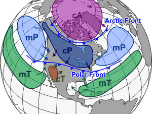
Notice on the Air Masses map that there aren’t stable air masses in the
center of the country. Now we
are going to look at why tornados develop commonly in this area.
2.
Play Why Do Tornados Hate America?
https://www.youtube.com/watch?v=0yiZveJAEp4
3.
What are the warm air masses that interact in Tornado Alley (maritime
tropical (hot and moist), continental tropical (hot and dry) and
continental polar (cold and dry).
Spinning comes from interacting winds plus coriolis effect.
4.
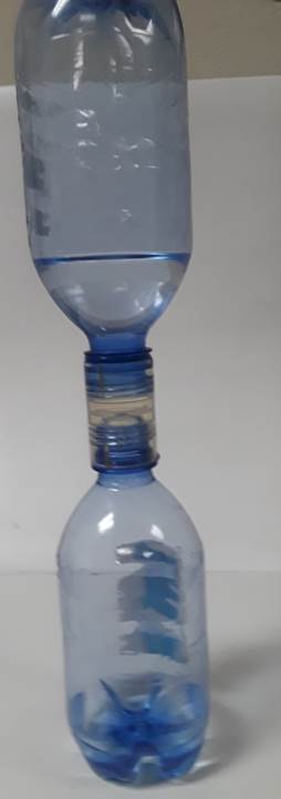
Now get to try out some aspects of tornados. Two water bottles connected
by a “tornado tube” connector with water about half way up in one.
5.
First, just turn the tornado tube upside-down with no circular movement.
What happens?
The water in the upper bottle will not drain due to air pressure in the
lower.
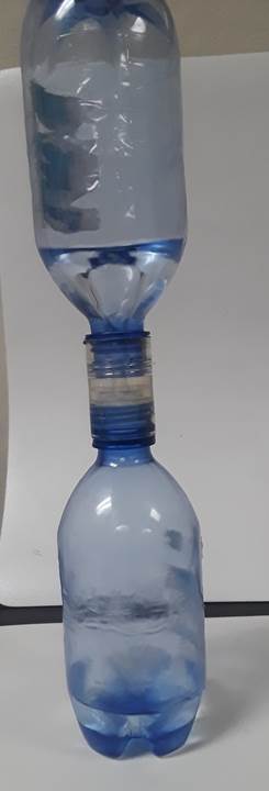
6.
However, if you rotate bottles you can produce a tornado in the upper
bottle which moves the water to the exterior and allows the air to come up
through the center. So water
can go down and air can come up at the same time.
This action is similar to the action of a real tornado, fast moving
air moving up while spinning.
7.
Let students experiment to see who can get the fastest drainage.
FINAL REVIEW:
1.
What did the balloon tell us?
High pressure air moves toward low pressure air creating wind.
2.
What creates large air masses that with similar characteristics?
Answer: where they are
formed on the globe-- if over water, the mass will be moist (maritime) If
over land it will be dry (continental).
If close to equator it will be hot.
If from polar region it will be cold.
3.
The underlying cause of winds and storms is the unequal heating of the
Earth's surface and the fact that the Earth rotates. But the amount of
heat varies considerably, and there are many other factors. This is the
reason why weather persons do not have a good record for predicting and
forecasting the weather. It’s a hard job!
No movement, no water drains
With spinning motion get “tornado above and fast drainage.
|
|||
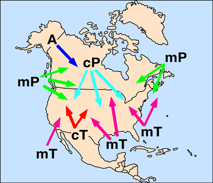 The type of air mass over an area is
dependent on the (1) latitude and (2) whether it is over a continental or
marine area. This exercise is just to familiarize students with the different
type of air masses that occur over the United States.
The type of air mass over an area is
dependent on the (1) latitude and (2) whether it is over a continental or
marine area. This exercise is just to familiarize students with the different
type of air masses that occur over the United States.