BACKGROUND:
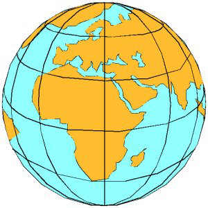
The planet Earth is approximately spherical in shape.
In terms of maps, this means that a globe most accurately portrays the shape
of the Earths surface. The Earths shape also effects the appearance of
latitude and longitude lines. As the cartoon globe above shows, latitude
(East-West) lines remain parallel from the Equator to the poles. In
contrast, longitude lines converge at the poles.
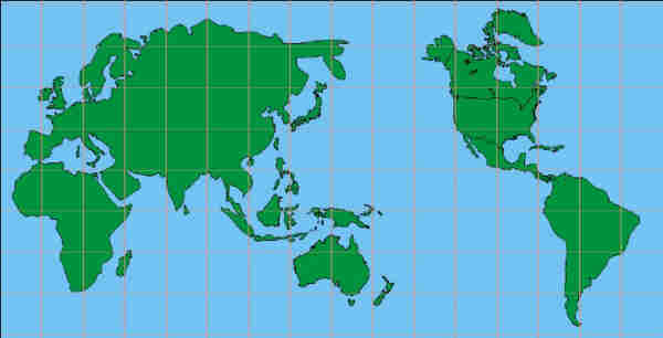
Flat maps distort the shape of the Earth because they
are two dimensional projections of the real three dimensional surface. For
example, a common flat map, called the Mercator projection, keeps lines of
both latitude and longitude parallel. It thus distorts the areas on the map.
For example a Mercator projection map makes Greenland look bigger than South
America, when the opposite is really true. There are many different types of
flat maps.
PROCEDURE:
-
Review latitude and longitude. Remind students that latitude lines run
East-West, and longitude lines run North-South. Explain that these lines
are the basis for locating where you are on the Earths surface.
-
Show the students a globe and a flat map (or project the map examples
on the following pages). Ask them to describe the differences between
them. Point out that the globe is a much more accurate model of the real
Earth, in terms of shape and distance. Have the students try to
distinguish some of the ways that flat maps distort shapes on the
"real" Earth. For instance, on a flat map, Greenland looks
very large, often bigger than South America. In reality it is much
smaller. Have the students look for other distortions.
The main
objective is for students to look and compare different types of maps.
You can compare and contrast any of the points of a globe on a flat map
depending on your background and the interest of the students.
-
Have the students compare latitude and longitude lines on the globe
and the different maps. They will see that longitude lines converge at
the poles on the globe. Near the poles on the flat maps, they remain
parallel, and are distorted.
You may want to make a chart of the student s observations.
| |
LATITUDE |
LONGITUDE |
|
globe |
horizontal lines, that are somewhat the same
thickness |
go from north to south pole, evenly space all over
the Earth |
|
flat map |
horizontal lines that are thicker in the north and
south region |
equal lines, from north to south vertical |
-
You may want students to use the worksheet and put in
longitude and latitude and then cut out their own puzzle of the world.
|