BACKGROUND:
According to folklore, Christopher Columbus was
practically the only person of his day who thought that the Earth was
spherical in shape. Actually, the ancient Greeks Pythagoras and Aristotle
both taught that the Earth was a sphere, and its diameter was calculated
within 50 miles of the correct value by Erastothenes in about 220 BC.
Educated people of Columbus' day were aware that the Earth was spherical.
The ancient Greeks used several lines of evidence to
demonstrate the spherical shape of the Earth. They noted that the Earth's
shadow on the Moon is curved during an eclipse, and ships going out of sight
on the ocean disappear from the bottom up, as they move past the horizon. In
1522 the concept was proved to everyone when one of Magellan's ships
returned to Europe, completing the first Western circumnavigation of the
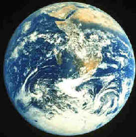
Earth. Today, pictures from spacecraft clearly demonstrate the spherical
shape of the Earth. Students may be used to this concept, from watching
media or video games.
We now know that the Earth is not a perfect sphere.
Because of its rotation, the Earth actually flattens out at the poles, and
bulges slightly at the equator. In reality, the Earth is thus slightly egg
or pear shaped.
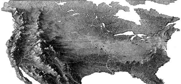
The Earth also differs from a perfect sphere in that
its surface is irregular. These changes in elevation on the Earths
surface, such as mountains, valleys, ocean basins, and plains, are called
relief. Relief is intuitively understood by children because they see
changes in the Earths surface whenever the go outside. In contrast, the
spherical shape of the Earth is not apparent.
PROCEDURE:
- Explain the that the Earth is spherical in shape.
You may wish to show them a globe, and pictures of the Earth from space.
Ask the students if they can see the spherical shape of the Earth when
they go outside. They should answer no. Discuss that early people
thought that the Earth was flat, because it looked that way.
Explain that it took many years for early
scientists to determine the shape of the Earth. Go through the reasons
of why we know it is spherical. Using the globe and toy boat, show the
children why a boat might disappear from the bottom up. Tell them that
they can see this if they watch a boat go over the horizon with a pair
of binoculars.
- Explain that the Earths surface has relief.
Introduce the following words to your students. Include any other words
that may be appropriate for your region.
HILL - A large "bump" on the
surface of the Earth, usually rounded on top. Use a local example that the
children might know.
MOUNTAIN - A larger
"bump" than a hill. A raised area is called a mountain if it is
more than 2000 feet above its surroundings. A smaller "bump" is
a hill.
VALLEY - A low, flat
area between mountains or mountain ranges.
BAY - A protective,
wide dent in the shore of an ocean or lake.
PENINSULA - Land that
sticks out into the water, surrounded by water on 3 sides.
PLAIN - A flat area that extends over hundreds of miles.
- Have the students explore the relief maps. Let them
use their fingers to find examples of the vocabulary words listed above.