BACKGROUND:
One of the first observations used to suggest that the
outer portion of the Earth is mobile is the fit of the continents,
particularly the west coast of Africa against the east coast of South
America. This observation predates plate tectonics. It was first noticed in
the 18th century, and proposed by a German scientist, Alfred
Wegener in 1912. Wegener called his theory called "continental
drift", referring to the apparent movement of continents alone.
However, "continental drift" is a historical term, that may give
the wrong notion to children. We now know It is not the continents that
move, but the plates, in which the continents are embedded. South America
and Africa were once together, but were split apart by the formation of a
diverging plate boundary. This is confirmed by matches between the rocks and
fossils of the two continents. Plate motion, not continents drifting,
explains this. The two continents are still moving away from each other
today.
Even through it has been established that the plates,
and thus the continents, have moved through time, many unanswered questions
remain on how the plates move, as well as where they have been in the past.
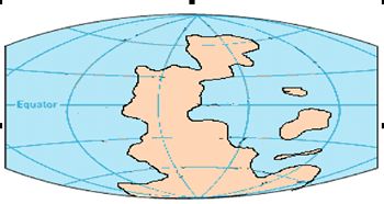
In this post lab, the students will examine maps which show the positions of
the plates and continents at several times over the past 510 million years.
The evidence for these locations is difficult to understand, but real. The
maps show only the continental parts of plates. The remainder, composed of
oceanic crust, is destroyed through time by subduction and collision at
convergent plate boundaries.
Several websites have excellent images of past plate
configurations.
http://www.scotese.com/ - The Paleomap
Project - detailed plate location reconstructions for the past 650 million
years. Also simple animations of plate motion.
PROCEDURE:
- Explain to the students that plate motions have made the continents
move through time. Make sure that they understand that the plates move,
and the continents ride on their backs.
- At the elementary school level the reason why geologists feel that the
maps are accurate cannot be explained effectively to students. Just try
to have fun with your class, and try to understand the differences
between the maps. Here are some suggested activities and questions:
- Have your students chart the differences from one time frame to
another.
- See if some continents have been at the equator at some point in
the past. (Yes, North America, 510 million years ago).
- Would the rocks on a continent record a different climate if the
continent was in a different place on the Earth? (Yes)
- Have your students make a "flip movie" by placing the
pictures in the chronological order. If you wish to do this
activity, we suggest you print the maps on thicker paper.
- If you have studied fossils in your class, you might want to
discuss whether or not the fossils in rocks can provide any clues
about the continents' past positions. (Yes, for example in
Antarctica, paleontologists have found fossil trees. Looking at the
maps, when could this have happened? 500-520 million years ago.)
- Which continents have moved a lot? North America, Australia
- Did we always have the Pacific Ocean and Atlantic Ocean? No
- Color one continent one color, and trace it throughout the
different maps This makes it easy to identify.
- Cover one of the maps on each sheet and see if your students can
recreate what the missing map should look like.