BACKGROUND:
Using a variety of instruments, geologists have
measured the directions and rates of plate movement at the surface of the
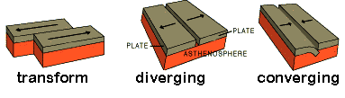
Earth. They have found that plates move in three basic ways. In some places,
two plates move apart from each other; this is called a diverging plate
boundary. Elsewhere two plates move together; this is a converging plate
boundary. Finally plates can also slide past each other horizontally. This
is called a transform plate boundary.
All of the plates move slowly. Their speeds vary from
a few millimeters per year to a maximum of 15 centimeters per year. On
average, the plates move about as fast as human fingernails grow.
Volcanoes and earthquakes help define the boundaries
between the plates. Earthquakes occur at all three types of boundaries.
Because the plates are rigid, they tend to stick together, even though they
are constantly moving. When the strength of the rocks at the plate boundary
is exceeded, they move rapidly, "catching up" with the rest of the
plates. We feel this release of energy as an earthquake. At diverging plate
boundaries, earthquakes occur as the plates pull away from each other.
Volcanoes form between the plates, as magma rises upward from the underlying
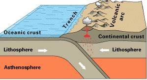
mantle. Two situations are possible at converging plate boundaries. First,
only earthquakes occur when two plates collide (obduct), building a mountain
range. Second, both volcanoes and earthquakes form where one plate sinks
under the other, instead of colliding. This process is called subduction.
Transform plate boundaries commonly have only earthquakes.
PROCEDURE:
-
Review the interior structure of the Earth with the class. Make sure
that they also understand that the plates are composed of the crust and
uppermost mantle - the lithosphere. In Exercise I below, the students
will draw the basic internal structure of the Earth.
-
In Exercise II, the students will simulate plate motions at each type
of plate boundary. Have the students imagine that they are "Mother
or Father Earth," who are feeling the pain of the moving Earth. As
they move the sand or clay, have them try to capture the slowness of
movements in the real Earth. We use clay and sand to represent the many
types of rocks that make up the plates, as well as the Earth's surface.
Here are some guidelines for Exercise II:
-
The slower the students do this exercise the better their results
will be. They will form parallel "mountains" by
compressing and sliding the sand or clay. At transform boundaries,
mostly earthquakes are produced; any mountains will be very small.
-
Diverging plate motion is difficult to show. Make sure that you
use a tub of sand that is large enough for the students to be able
to move their hands in it. If done slowly, the students will realize
that you cannot pull the earth apart without the "tear"
replacing itself with "lava," here represented by sand.
Diverging plate boundaries thus produce both earthquakes and
volcanoes.
-
Converging plates will produce mountain chains. In this case, you
will get earthquakes.
-
Conclude with the class that plate motions are associated with
earthquakes and volcanoes. Explain that scientists (geologists) use
plate tectonics to explain the movement of the Earth's crust. Illustrate
the three different crust movements on the chalkboard and a wall map to
point out some of the boundaries.
ANSWERS:
-
Transform: clay: cracks in clay, sand: valleys and hill; model of
San Francisco area, San Andreas Fault
-
Diverging: forms mountains, volcanoes; example Iceland
-
Converging: clay forms mountains and valleys that are parallel;
sand forms same structural form; example: parts of California's
Coast Ranges
Conclusion: (1) B; (2) A, B, C; (3) B
|