BACKGROUND:
Plate boundaries are marked by numerous volcanoes and
earthquakes. The pattern of occurrence of these events is one of the key
pieces of evidence for plate tectonics.
In this exercise, the students will examine the
pattern of earthquakes and volcanoes at occur in the Atlantic Ocean. Most of
these occur at the diverging plate boundary that runs north-south through
the ocean. The remainder are at two east-west running transform and
converging plate boundaries that goes through the Mediterranean Sea to the
east and the Caribbean Sea to the west.
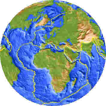
The diverging plate boundary occurs at an underwater
mountain range called the Mid-Atlantic Ridge. The center of this mountain
range is a low lying area or rift, called the Atlantic Rift Zone. This is
the actual plate boundary, and is where most of the earthquakes and
volcanoes take place. The shape of this plate boundary mimics the shapes of
the continents on either side of it, especially Africa and South America,
because these areas of crust were together before the diverging plate
boundary formed.
PROCEDURE:
The point of the exercise is for students to see that
earthquakes and volcanoes mark the plate boundaries, and that the shapes of
the diverging boundaries match the edges of the areas from which they
formed.
- Tell the students that earthquakes and volcanoes
occur within the dotted areas on the worksheet. Make sure that they
notice that the continents are not near these boundaries in most places,
especially North America, South America, and Africa.
Tell the students to trace the boundaries of the
moving plates by connecting the dots. Ask them if they recognize any
connections or patterns between the fit of the continents and the
position of the earthquakes and volcanoes. Hopefully they can see that
the pattern of earthquakes and volcanoes mimics the edges of the
continents. especially between South America and Africa. Tell them that
this pattern marks the diverging plate boundary from which these
continents, as well as Europe and North America, have split.
- Explain to the students that in the Atlantic Ocean
this zone of volcanoes and earthquakes is similar to the fit of the
continents. Tell them it is called the Atlantic Rift Zone. You may wish
to show them maps of the ocean floor and plate boundary.
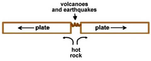
- Draw the diagram. Ask your students to explain what
they think will happen if the mantle convection currents pull in
opposite directions. Explain that the hot rock will come up and form
volcanoes. Ask them where in the Atlantic Ocean area the volcanoes are
located. The volcanoes are under the ocean, on the sea floor. Iceland is
an exception: here the volcanoes are on land. You may wish to show them
the presentation image of the Atlantic Ocean region below. It shows the
Mid Atlantic Ridge clearly.