BACKGROUND:
The Plate Tectonic Cycle exercises stress the
information that earthquakes and volcanoes give us about plate boundaries
and plate motions. However, many other types of evidence also support the
theory of plate tectonics.
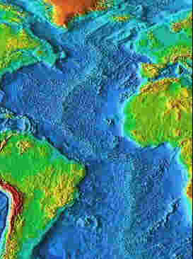
One of the first observations used to suggest that the
outer portion of the Earth is mobile is the fit of the continents,
particularly the west coast of Africa against the east coast of South
America. This observation predates plate tectonics. It was first noticed in
the 18th century, and most recently proposed by a German
scientist, Alfred Wegener in 1912. Wegener called his theory the
"continental drift" theory, referring to the apparent movement of
continents alone. However, "continental drift" is a historical
term that may give the wrong notion to children. We now know it is not the
continents that move, but the plates, in which the continents are embedded.
South America and Africa were once together, but were split apart by the
formation of a diverging plate boundary. This is confirmed by matches
between the rocks and fossils of the two continents. Plate motion, not
continents drifting, explains this. The two continents are still moving away
from each other today.
In this handwriting, coloring, and cutting exercise
the students will discover that South America fits into Africa, much like a
jigsaw puzzle.
PROCEDURE:
- Remind your students that the continents riding on the backs or top
parts of the plates. Show them a map of South America and Africa, or use
the presentation image below. Ask your students if they believe these
two continents were joined together. Hopefully they will see the
geometric fit. Remind the class that this is one piece of evidence for
plate tectonics. Many other pieces of information were needed to
"prove" the theory.
- If you have a large world map in your room, go over the different
continents with your students and have them try to fit other continents
and areas together. If you rotate North America toward the right it fits
against Europe. The south coast of Australia fits against Antarctica.
India fits between Africa and Australia.
- Have the students complete the worksheet. They should trace the names
of the continents first, to practice their writing skills. Have them
color the continents before they cut them out.