BACKGROUND:
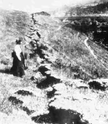
Earthquake faults are zones of weakness, that
"break" when stress builds up and needs to "relieve"
itself. Most faults are actually zones of movement that can be hundreds of
meters in width.
California is well-known for its earthquakes, both in
the southern and northern parts of the state. The most famous fault in
California is called the San Andreas Fault. It runs northwest to southeast
near the coast, extending from offshore north of San Francisco, all the way
to Baja California in Mexico. This fault marks the plate boundary between
the North American plate to the east and the Pacific Plate to the west.
These two plates are currently sliding past each other. The Pacific Plate is
moving northwest relative to the North American plate.
In the San Francisco Bay area, the motion between the
two plates is distributed between three major faults. These are:
- The San Andreas Fault, roughly follows a line running from San Juan
Bautista, between Watsonville and Gilroy, between San Jose and Los
Gatos, and then following I-280 and Highway 35 before going out to sea
at Mussel Rock in Daly City. It reappears onshore east of the Point
Reyes Peninsula, separating it from the mainland. Here it runs from
Bolinas Lagoon and cuts a straight valley to northwest to Tomales Bay.
-
 The
Hayward Fault trends along the east side of San Francisco Bay. North to
south, it runs from just west of Pinole Point on the south shore of San
Pablo Bay and through Berkeley (just under the western rim of the
University of California’s football stadium). The Berkeley Hills were
probably formed by an upward movement along the fault. In Oakland the
Hayward Fault follows Highway 580 and includes Lake Temescal. North of
Fremont’s Niles District, the fault runs along the base of the hills
that rise abruptly from the valley floor. In Fremont the fault runs within
a wide fault zone. Southward, the fault lies between the lowest, most
westerly ridge of the Diablo Range and the main mountain ridge to the
east. Coyote reservoir, Leroy Anderson reservoir, and San Felipe Lake all
lie on the fault. It joins the San Andreas Fault near Hollister. The
Hayward Fault trends along the east side of San Francisco Bay. North to
south, it runs from just west of Pinole Point on the south shore of San
Pablo Bay and through Berkeley (just under the western rim of the
University of California’s football stadium). The Berkeley Hills were
probably formed by an upward movement along the fault. In Oakland the
Hayward Fault follows Highway 580 and includes Lake Temescal. North of
Fremont’s Niles District, the fault runs along the base of the hills
that rise abruptly from the valley floor. In Fremont the fault runs within
a wide fault zone. Southward, the fault lies between the lowest, most
westerly ridge of the Diablo Range and the main mountain ridge to the
east. Coyote reservoir, Leroy Anderson reservoir, and San Felipe Lake all
lie on the fault. It joins the San Andreas Fault near Hollister.
- The Calaveras Fault branches eastward from the Hayward fault near
Gilroy. It runs in a fairly straight line that points toward
north-northwest towards Vallejo. It may continue north of San Pablo Bay.
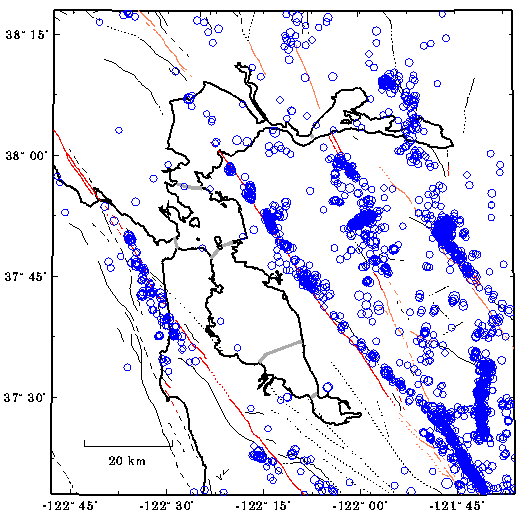
A color map of these faults follows this material. You may wish to
project it to orient the students. We have also included a map showing all
Bay Area earthquakes from 1980 through 1997. The correspondence between
faults and earthquakes should be apparent.
On October 17, 1989, a Magnitude 7.1 earthquake struck the San Andreas
Fault near Santa Cruz. The 8.3 earthquake in 1906 occurred underwater,
just north of San Francisco. It was also on the San Andreas Fault.
In this exercise the students will trace these faults in the San
Francisco Bay area by pasting yarn on the map provided.
PROCEDURE:
- Show the students a map of the United States so that they can locate
California. If you have a relief map of the San Francisco Bay area, show
them that the faults follow the topography (hills and valleys) of the
region. If you have a relief map of California, you may want to show the
students how the mountain ranges are mainly parallel to each other.
- Give students yarn, scissors, and paste. Have them cut the appropriate
length.
- Have the students color the land brown and/or green on their maps.
Instruct them to glue strips of a bright colored yarn over the fault
lines on the map.
- If you live in the San Francisco area, have the students locate where
they live. See which fault is the closest to their home or school.
Discuss what other structures are close to the faults, like big cities,
railroads, or airports.
- If you do not live in the San Francisco Bay area, you may want to find
a local fault map of your region. You can consult your local university
geology department. If you have trouble locating a map, please email us
(msn@msnucleus.org) and we will try to help you.
|