|
PROBLEM: Can you define the different features of the ocean
bottom?
HYPOTHESIS:
MATERIALS:
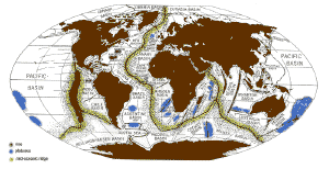
hydrographic globe showing the ocean bottom, globe,
worksheets
Click on picture to enlarge
PROCEDURE: Use appropriate maps to answer the following questions
either on the map or space provided.
1. Orient your map or globe to point north. What is the name of the
northernmost ocean?
What types of features can you see on this ocean floor?
2. What is the name of the ocean between North America and Africa?
What is the major ocean floor feature in this ocean?
What caused this feature to form?
What other types of sea floor features can be found in this ocean?
3. Find the Indian Ocean. In what direction do the fault lines run?
What does the Y-shaped feature in the Indian Ocean represent?
4. Find an ocean trench. Islands are usually associated with ocean
trenches. Name some island chains that lie on ocean trenches (clue:
South Pacific Islands).
5. What is the name of the major feature that is to the immediate
left of the United States? What could have caused this feature to form?
6. List all the basins named on the map. List them under the
appropriate ocean (i.e., Atlantic).
7. MID-OCEANIC (Atlantic) RIDGE SEISMIC PROFILE:
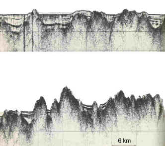
Describe where the sediments are located.
The Mid-Atlantic Ridge is commonly described as an arch that is
broken by faults. What do the faults look like in this profile?
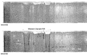
8. FRACTURE ZONES:
Click on picture to enlarge
The top picture is a seismic profile in the Red Sea. The bottom is
the interpretation. See if you can find the clues that allow for the
bottom interpretation. See if you can mentally see these faults.
CONCLUSION: What features were the easiest and the most difficult
to identify?
|