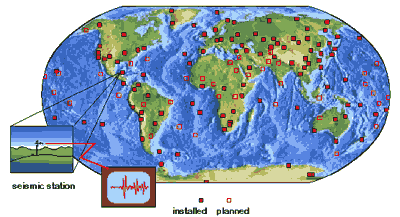
 Scientists of the U.S. Geological Survey (USGS) have operated seismographic
stations throughout the world for more than 35 years. They work with
other scientists in over 80 countries in the Global Seismographic Network. The
principal use of seismograph networks is to locate earthquakes. Although it is
possible to infer a general location for an event from the records of a single
station, it is most accurate to use three or more stations.
Scientists of the U.S. Geological Survey (USGS) have operated seismographic
stations throughout the world for more than 35 years. They work with
other scientists in over 80 countries in the Global Seismographic Network. The
principal use of seismograph networks is to locate earthquakes. Although it is
possible to infer a general location for an event from the records of a single
station, it is most accurate to use three or more stations.
When an earthquake occurs, data from the
seismographs feeds into a major research center, where the seismograms
are analyzed. This analysis determines where the earthquake occurred,
and determines its magnitude. Major earthquake data centers in the
United States include Menlo Park and Los Angeles, both in California,
and Boulder, Colorado.
|