|
 The
Fremont Earthquake Exhibit The
Fremont Earthquake Exhibit
2023-24
field trips for 3rd grade-college
Book
field trips by calling (510)790-6284 or email
msn@msnucleus.org
Cost: $225.00
up to 30 people
1.5 hour tour
fall and spring
time trip available only
SPECIAL EVENT - OCT 10, FIELD
TRIP FOR JUNIOR HIGH (FREE)
Earthquake
Awareness - Grant from Alameda County District 1, Dave
Haubert
OPEN HOUSE - Free to the
public October 21, 2023
WHAT YOU WILL SEE
 The field trip starts at the Fremont Earthquake Exhibit (back
part of the Fremont Community Center) on Paseo Padre and Mission
View. Students will see a crack through the foundation and
look at about 1.5 inches of offset. We discuss the Hayward
Fault and other information appropriate to audience.
The trip continues outside to walk about 1 mile to see the
various "clues" in which the earthquake fault is outlined.
Included are up to 3 inches of offset. The field trip starts at the Fremont Earthquake Exhibit (back
part of the Fremont Community Center) on Paseo Padre and Mission
View. Students will see a crack through the foundation and
look at about 1.5 inches of offset. We discuss the Hayward
Fault and other information appropriate to audience.
The trip continues outside to walk about 1 mile to see the
various "clues" in which the earthquake fault is outlined.
Included are up to 3 inches of offset.
Participants will never look at cracks in the street the same
way. En enchelon patterns and offsets can be seen
throughout Central Park in Fremont. We will visit the site
of the former City Hall that was taken down because it was built
in the wrong location. We will discuss how the County Main
Library was built to take care of a possible shaker.
The tour was designed by Dr. Joyce Blueford, a geologist, who
incorporates history of the east bay and discusses how the
faults are responsible for our present landscape.
Each grade has different emphasis from more historical (3rd
grade) to scientific (college). Look at the
"Walk" to see
specific information at each station.
Since the tour is at Fremont's Central Park,there are picnic
tables and bathrooms that you can use for your class and make an
enjoyable and educational day.
BACKGROUND
The Hayward Fault is a major fault of concern in the East Bay.
It has been considered the most dangerous area for a
possible major seismic event by the U.S. Geological Survey.
There is a one in three chance of a major earthquake of
6.8 or greater on the Hayward Fault within the next 30 years.
The last major quake in this area was on
October 21, 1868, with a magnitude of 7.0, which
ripped almost a continuous shear of about 6 feet from Milpitas to Oakland.
The
City of Fremont was incorporated in 1956.
Unknowingly they built their first building, the
Fremont
Community Center
on the
Hayward Fault.
Within 10 years they noticed that the floor was
cracking.
They first thought that it was only due to poor construction but
then they realized there was an offset to a set of cracks.
After 10 years they had to close this area to the public,
closing down a Children’s Theater.
Over the years it has grown into a 1-2 inches of offset.
The Math Science Nucleus in collaboration with
the City of Fremont and the U.S.
Geological Survey have created a “Faulted
Floor” exhibit to be part of a general earthquake trail
tour throughout Central Park.
There are currently two tours. One through Fremont
Recreation Department that includes a walk through Central Park
(click here for more information)
and a more scientific and longer
walk
from Tule Ponds at Tyson Lagoon to the exhibit
showing natural earthquake features (sag ponds, fault scarps)
and urban features (offset curbs, moving of asphalt, compression
ridges) in Central Park (contact
Math Science Nucleus
msn@msnucleus to arrange dates).
Both include the "Faulted Floor."
This City of Fremont walled off
600 square feet including walls to help us
dramatize the science of earthquakes.
The facility will be used for field trips for K-college
by the Math Science Nucleus.
The City of Fremont will also use the area when there are
events in the park so people can look at the exhibit to learn
the science behind earthquakes as well as learn about earthquake
preparedness. Volunteers
and staff from the Math Science Nucleus will conduct the tours.
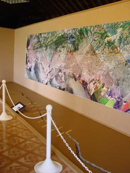
the U.
S. Geological Survey to create a large map of the
East Bay.
Visitors will be able to locate their house in
relationship to the fault while stepping over the “crack.”
A project of
Math Science
Nucleus
The City of Fremont and U.S. Geological Survey
Any questions please
email us at msn@msnucleus.org
 |
 MATH SCIENCE NUCLEUS
since 1982 has served the education and public by
offering quality science and math lessons that take our
children learn critical thinking skills. We manage the
Children's Natural History Museum and Tule Ponds at
Tyson Lagoon Wetland Center.
http://msnucleus.org. MATH SCIENCE NUCLEUS
since 1982 has served the education and public by
offering quality science and math lessons that take our
children learn critical thinking skills. We manage the
Children's Natural History Museum and Tule Ponds at
Tyson Lagoon Wetland Center.
http://msnucleus.org.
Math Science Nucleus received partial funding from PGE
for the Faulted Floor Exhibit. |
 |
U.S. GEOLOGICAL SURVEY
is a government agency that Federal
source for science about the Earth, its natural and
living resources, natural hazards, and the environment.
They provide the posters and map for the Faulted Floor
Exhibit. http://usgs.gov
|
Next Generation Science Standards
Correlation
4-ESS2.B:
Plate Tectonics and
Large-Scale System Interactions
The locations of mountain ranges,
deep ocean trenches, ocean floor structures, earthquakes, and
volcanoes occur in patterns. Most earthquakes and volcanoes
occur in bands that are often along the boundaries between
continents and oceans. Major mountain chains form inside
continents or near their edges. Maps can help locate the
different land and water features areas of Earth. (4-ESS2-2)
4-ESS3.B:
Natural Hazards
A variety of hazards result from natural processes (e.g.,
earthquakes, tsunamis, volcanic eruptions). Humans cannot
eliminate the hazards but can take steps to reduce their
impacts. (4-ESS3-2)
MS-ESS2.B:
Plate Tectonics and Large-Scale System Interactions
Maps of ancient land and water patterns, based on investigations
of rocks and fossils, make clear how Earth’s plates have moved
great distances, collided, and spread apart. (MS-ESS2-3)
[Earthquake] |